| Date: | 1867 |
|---|---|
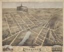
| Description: | Bird's-eye map of Green Bay and Fort Howard, Brown Co., depicts street names and street layouts, houses, trees, and the East River. A reference key at the ... |

| Date: | 1898 |
|---|---|
| Description: | Bird's-eye map of Milwaukee with prominent streets and buildings identified. Taken from City Hall Tower. |

| Date: | 1883 |
|---|---|
| Description: | Bird's-eye map of Superior, county seat of Douglas County, on the shores of Lake Superior, with insets of points of interest. |

| Date: | 1878 |
|---|---|
| Description: | Bird's-eye map of Chilton with insets of points of interest, including P.H. Becker's Brewery, Chilton House, and Gutheil's Block. |

| Date: | 1874 |
|---|---|
| Description: | Bird's-eye map of Chippewa Falls. |

| Date: | 1880 |
|---|---|
| Description: | Bird's-eye map over the Mississippi River of Fountain City. Paddle steamers and steamboats are on the river, and bluffs are in the background. |

| Date: | 1878 |
|---|---|
| Description: | Bird's-eye map of Kewaskum. Includes a list of hotels, churches, post office, railroad depot, etc. |

| Date: | 1896 |
|---|---|
| Description: | Bird's-eye view of Washburn, with twenty vignettes around side, water in foreground with docks and lumber corral. Thirty-three locations identified in key ... |

| Date: | 1874 |
|---|---|
| Description: | Bird's-eye view of Waukesha, looking southwest, with insets of State Industrial School, Court House, and Fountain Spring House. |

| Date: | 1870 |
|---|---|
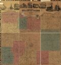
| Description: | A map of Iowa County, Wisconsin mounted on cloth that shows the villages of Avoca, Mifflin, Linden, Arena, Helena Station, Highland, Dodgeville, as well as... |

| Date: | 1930 |
|---|---|
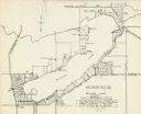
| Description: | Shows roads, fire stations, golf course, and accommodations around Delavan Lake. "The drive around the lake is divided into zones from 0 to 900 as shown. P... |

| Date: | 1898 |
|---|---|
| Description: | Map showing the contour depths of the lakes in northwestern Waukesha County, Wisconsin. Roads, railroads, depots, churches, schools, and hotels in the area... |

| Date: | 1915 |
|---|---|
| Description: | This 1915 map covers the section of the Wisconsin River in southern Adams, southeastern Juneau, northeastern Sauk, and northwestern Columbia counties. A po... |

| Date: | 1891 |
|---|---|
| Description: | This maps has an index of depots, hotels, prominent institutions and buildings, churches, and places of amusement. The map was removed from an unidentified... |

| Date: | 1800 |
|---|---|
| Description: | Shows plat of town, land ownership by name, local streets, courthouses, churches, hotels, mills, railroads, railroad stations, lakes, and rivers. Includes ... |

| Date: | 1907 |
|---|---|
| Description: | Shows public buildings, hotels, fraternity houses, and private houses. Index of fraternities and sororities, residences, public buildings, hotels, places o... |

| Date: | 1927 |
|---|---|
| Description: | Map reads: "Now You Can Visualize Madison". Includes indexes, with points marked 1-98 and a key. Text and illustrations on verso include hotels and seasona... |

| Date: | |
|---|---|
| Description: | Map and advertisement for the Casa del Norte Tea Rooms, with a grid of several blocks in downtown Duluth highlighting the tea rooms as well as other notabl... |
If you didn't find the material you searched for, our Library Reference Staff can help.
Call our reference desk at 608-264-6535 or email us at: