 Filter: Categories of Wisconsin Historical Images
Filter: Subject of Hospitals
Filter: Year of 1800-1899
Filter: Categories of Wisconsin Historical Images
Filter: Subject of Hospitals
Filter: Year of 1800-1899

| Date: | 1834 |
|---|---|
| Description: | This map is pen, ink, and pencil on paper and shows plat of the town, local streets, mills, forts, hospitals, and parts of Devil River and Fox River. |

| Date: | 1893 |
|---|---|
| Description: | This map shows wards, railroads, street cars, streets, lot and block numbers, landownership, parks, hospitals, the Sheboygan River, and Lake Michigan. Ward... |

| Date: | 1879 |
|---|---|
| Description: | This map shows asylums, cemeteries, hospitals, parks, streets, and wards. Relief is shown by contours. Also included are manuscript annotations in pencil. ... |
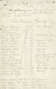
| Date: | 10 24 1862 |
|---|---|
| Description: | First page of a list of sick and wounded Wisconsin soldiers from the First Wisconsin Cavalry found at the Fifth St. Hospital in St. Louis by Cordelia Harve... |

| Date: | 1885 |
|---|---|
| Description: | View of the Wisconsin Hospital for the Insane and grounds. In 1935 it became the Mendota State Hospital. It was built in 1860 by architect Stephen Vaughn S... |

| Date: | 1861 |
|---|---|
| Description: | Shaded drawings with size dimensions for plans of "Tents used in Civil War. U.S. Army Regulation Tents." Upper left, "18. ft diam, Gilbert Anderson Hub... |
If you didn't find the material you searched for, our Library Reference Staff can help.
Call our reference desk at 608-264-6535 or email us at: