 Filter: Categories of Wisconsin Historical Images
Filter: Subject of Hospitals
Filter: Subject of roads
Filter: Subject of water
Filter: Categories of Wisconsin Historical Images
Filter: Subject of Hospitals
Filter: Subject of roads
Filter: Subject of water

| Date: | 1990 |
|---|---|
| Description: | This late 20th century tourist map of Sauk County, Wisconsin, shows the highways and roads, cities and towns, parks, airports, canoe landings, hospitals, s... |

| Date: | |
|---|---|
| Description: | A hand-drawn map of Camp Curtis which was prepared for Colonel R. McMurphy. |
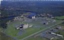
| Date: | 1950 |
|---|---|
| Description: | Aerial view of Sacred Heart Hospital. |

| Date: | 1956 |
|---|---|
| Description: | This map shows local streets, roads, railroads, highways, parks, cemeteries, hospitals, the University of Wisconsin, Middleton, Maple Bluff, Shorewood Hill... |

| Date: | 1960 |
|---|---|
| Description: | This map shows U.S. highways, state highways, county highways, town roads, county parks, county highway buildings, waysides, rivers, lakes, airports, a civ... |

| Date: | 1789 |
|---|---|
| Description: | Map of New York City showing ward boundaries, ferries, streets, roads, swamps, ponds, and rivers. The properties of Lispinard, Byards, Jones, Rutgers, and ... |

| Date: | 1967 |
|---|---|
| Description: | Air view looking north toward Lake Mendota. The intersection of West Washington Ave. and S. Park Street is at bottom center. The Triangle Redevelopment Pro... |
If you didn't find the material you searched for, our Library Reference Staff can help.
Call our reference desk at 608-264-6535 or email us at: