 Filter: Categories of Wisconsin Historical Images
Filter: Subject of Hospitals
Filter: Subject of human settlements
Filter: Categories of Wisconsin Historical Images
Filter: Subject of Hospitals
Filter: Subject of human settlements

| Date: | 10 31 2003 |
|---|---|
| Description: | "With continued pain in the right knee, the Fish Fry photographer is slated for a knee replacement on October 28 at The Kennedy Center, Mercy Medical Cente... |
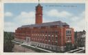
| Date: | |
|---|---|
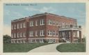
| Description: | Colorized postcard of the Memorial Hospital. Text at top left reads: "Memorial Hospital, Burlington, Wis." |
| Date: | |
|---|---|
| Description: | Color photographic postcard of the east side of Langlade County Memorial Hospital. |
| Date: | 09 19 1935 |
|---|---|
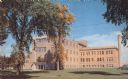
| Description: | Color postcard of the front entrance to the hospital. Caption reads: "Langlade County Memorial Hospital, Antigo, Wis." |
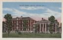
| Date: | 1922 |
|---|---|
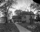
| Description: | View of Parker Hospital from the walkway. Leaves cover the lawn. There is a lawn swing in the yard. |
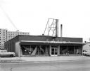
| Date: | 03 09 1954 |
|---|---|
| Description: | Exterior view of Hendrickson's Modern Home Furnishing Store at 2570 University Avenue, taken for the store's grand opening. The VA hospital is in the backg... |
| Date: | |
|---|---|
| Description: | Exterior view of the front facade and grounds of the four-story, red brick St. Joseph Hospital. |
| Date: | |
|---|---|
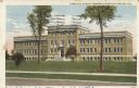
| Description: | Exterior view of the building and grounds of the Ashland General Hospital. |

| Date: | 1932 |
|---|---|
| Description: | Elevated view of one automobile parked on Main Street. The Legion Memorial Park is across the street. There is a hospital building in the background. Trees... |
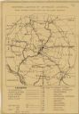
| Date: | 1920 |
|---|---|
| Description: | This map produced just after Word War I shows the proposed location for a veterans' hospital in the Eau Claire-Chippewa Falls region. Highways, rail lines ... |

| Date: | 1926 |
|---|---|
| Description: | View across street of the Dodgeville General Hospital on the corner of Chapel and Iowa Streets. Along Iowa street, there is a John H. Owen's general store,... |

| Date: | 1926 |
|---|---|
| Description: | Elevated view of exterior of Saint Joseph's Hospital. The three-story building has a cross on the roof over the entrance. |

| Date: | |
|---|---|
| Description: | Exterior of the two-story Hansberry Hospital, where three cars and a motorcycle are parked in the adjacent lot. |

| Date: | 1976 |
|---|---|
| Description: | A street map of Milwaukee County, Wisconsin that identifies the location of schools, hospitals, parks, beaches, streets, freeways, both planned or under co... |

| Date: | 1993 |
|---|---|
| Description: | A map of Milwaukee County, indicating the locations of toxic sites and the types of toxic sites, ranging from those listed as a superfund site, industry re... |

| Date: | 1990 |
|---|---|
| Description: | This late 20th century tourist map of Sauk County, Wisconsin, shows the highways and roads, cities and towns, parks, airports, canoe landings, hospitals, s... |

| Date: | |
|---|---|
| Description: | View of the Beloit Hospital from an intersection. There are people sitting on a second floor balcony in a building on the corner. A person is riding a bicy... |

| Date: | 1908 |
|---|---|
| Description: | Panoramic view of Madison taken from Summit Avenue looking East South East toward Lake Monona. Included in the view are the Camp Randall bleachers, St. Rap... |

| Date: | 09 04 1957 |
|---|---|
| Description: | A tour guide shows new St. Mary's Hospital School of Nursing students around Madison. Viewing Vilas Park and Lake Wingra are, left to right: Sheila Deseve,... |

| Date: | 1831 |
|---|---|
| Description: | Map of the city of Louisville, Kentucky on the Ohio River showing streets and numbered lots. The Ohio River, Corn Island, and the Louisville and Portland C... |
If you didn't find the material you searched for, our Library Reference Staff can help.
Call our reference desk at 608-264-6535 or email us at: