 Filter: Categories of Wisconsin Historical Images
Filter: Subject of Hospitals
Filter: Subject of human settlements
Filter: Year of 1900-1999
Filter: Year of 1960-1969
Filter: Categories of Wisconsin Historical Images
Filter: Subject of Hospitals
Filter: Subject of human settlements
Filter: Year of 1900-1999
Filter: Year of 1960-1969
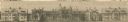
| Date: | 11 23 1960 |
|---|---|
| Description: | Sheboygan County Hospital, also known as Park Lawn for awhile; built in 1882, razed in 1960. This excerpt from the Sheboygan Press is depicting the Hospita... |
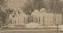
| Date: | 11 23 1960 |
|---|---|
| Description: | Sheboygan County Hospital, also known as Park Lawn for awhile, was built in 1882, razed in 1960. This excerpt from the Sheboygan Press is depicting the Hos... |
| Date: | 1966 |
|---|---|
| Description: | St. Mary's Hospital and surrounding area. In the bottom left corner is the water tower. |

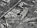
| Date: | 1960 |
|---|---|
| Description: | Aerial view of the Dane County Hospital, looking north. Excavating for a more modern east wing that was finished in 1960 can be seen. It had been called t... |

| Date: | 06 14 1961 |
|---|---|
| Description: | Forty-three nursing students in the Madison General Hospital School of Nursing Class of 1963 begin the two-year clinical phase of their nursing education. ... |

| Date: | 1965 |
|---|---|
| Description: | This map shows streets, churches, schools, wards, railroads, parks and fields, cemeteries, Historical Museum, Yacht Basin & Marina, and Marinette General H... |

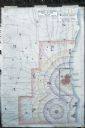
| Date: | 1960 |
|---|---|
| Description: | This map shows U.S. highways, state highways, county highways, town roads, county parks, county highway buildings, waysides, rivers, lakes, airports, a civ... |

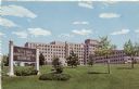
| Date: | 1960 |
|---|---|
| Description: | View across field towards the Sacred Heart Hospital at 900 W. Clairemont Avenue, (Hwy 12 at Jct. 37 & 85). |
| Date: | 1963 |
|---|---|
| Description: | Exterior view of a VA Hospital from across a lawn with small trees. |

| Date: | 1967 |
|---|---|
| Description: | Air view looking north toward Lake Mendota. The intersection of West Washington Ave. and S. Park Street is at bottom center. The Triangle Redevelopment Pro... |

| Date: | 1964 |
|---|---|
| Description: | Aerial view of the Sampson Plaza apartment complex on West Washington Avenue, with Proudfit Street running along the bottom. Neighborhood House can be seen... |
| Date: | 1960 |
|---|---|
| Description: | Map showing the probable blast radius of a 20 megaton bomb on Milwaukee. The map also shows existing hospitals in the area, including outside Milwaukee Cou... |
If you didn't find the material you searched for, our Library Reference Staff can help.
Call our reference desk at 608-264-6535 or email us at: