 Filter: Categories of Wisconsin Historical Images
Filter: Subject of Hospitals
Filter: Subject of fortification
Filter: Categories of Wisconsin Historical Images
Filter: Subject of Hospitals
Filter: Subject of fortification

| Date: | 1842 |
|---|---|
| Description: | This hand-colored lithograph of the second Fort Howard, with Indians canoeing on the Fox River, shows the hospital built 1834-1835 outside the stockade on ... |
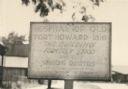
| Date: | 1925 |
|---|---|
| Description: | Fort Howard Hospital Marker. "Hospital of old Fort Howard - 1816. This building formerly stood with the surgeons quarters and the powder magazine on the ri... |

| Date: | |
|---|---|
| Description: | "Hospital and (indecipherable) during the last days battle at Fort Donelson on the Tennessee." Building with people and several trees. |

| Date: | 1834 |
|---|---|
| Description: | This map is pen, ink, and pencil on paper and shows plat of the town, local streets, mills, forts, hospitals, and parts of Devil River and Fox River. |

| Date: | 07 28 1934 |
|---|---|
| Description: | This map shows buildings and dimensions of Fort Crawford and hospital overlaid on a plat of existing lots, streets, and closed streets. |

| Date: | 1760 |
|---|---|
| Description: | Map showing upstate New York, Lake Ontario, and the St. Lawrence River during the last, decisive battle of the French and Indian War. The main map shows a ... |
If you didn't find the material you searched for, our Library Reference Staff can help.
Call our reference desk at 608-264-6535 or email us at: