 Filter: Categories of Wisconsin Historical Images
Filter: Subject of Historic sites
Filter: Subject of trails
Filter: Categories of Wisconsin Historical Images
Filter: Subject of Historic sites
Filter: Subject of trails
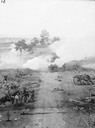
| Date: | 1889 |
|---|---|
| Description: | Stereograph from the Chicago Panorama of the Battle of Gettysburg Representing Pickett's Charge at 4 P.M., July 3rd, 1863: Pike Leading from Cemetery Hill,... |
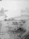
| Date: | 1889 |
|---|---|
| Description: | Stereograph from the Chicago Panorama of the Battle of Gettysburg Representing Pickett's Charge at 4 P.M., July 3rd, 1863: Woodruff's Battery on the Right ... |
| Date: | |
|---|---|
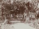
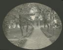
| Description: | View of the East Walkway at Villa Louis. The walk is lined with trees and flower beds. |
| Date: | |
|---|---|
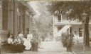
| Description: | View of the east terrace at Villa Louis. The Dousman's office building is in the background. Relaxing near the home are Louis DeVierville Dousman, Judith D... |

| Date: | |
|---|---|
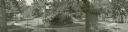
| Description: | South lawn looking west from gazebo toward fountain. A path crosses the foreground, and the Dousman's dog, Folo, lounges on the lawn. |

| Date: | |
|---|---|
| Description: | Elevated panoramic view of the west lawn at Villa Louis. Several trees and shrubs, a flag pole, and a swimming hole can be seen in the yard. A pontoon rail... |
| Date: | |
|---|---|
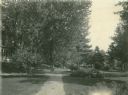
| Description: | View along the path leading to the east entrance at Villa Louis. The herringbone pattered brick path is lined with trees and coleus plants. |
| Date: | |
|---|---|
| Description: | Composite panoramic view showing gazebo, star bed, and southeast corner of the lawn. |
| Date: | 1904 |
|---|---|
| Description: | East view of round canna bed and grotto on Villa Louis grounds. The house can be seen at left. |

| Date: | |
|---|---|
| Description: | Panoramic view of southwest corner of Villa Louis lawn. The house and a path can be seen at right. |

| Date: | |
|---|---|
| Description: | Panoramic view of the east lawn at Villa Louis. The house and office building can be seen at right. |

| Date: | |
|---|---|
| Description: | Exterior view of Howland House, a colonial dwelling. Text on the sign outside the house reads, "Oldest House in Plymouth, Built 1667-Restored 1913, The la... |

| Date: | 1975 |
|---|---|
| Description: | This 1975 road map of Columbia County, Wisconsin, shows the location of historic sites in the county but lacks a key to those sites. It includes an inset m... |

| Date: | 1996 |
|---|---|
| Description: | This map shows roads, lakes, points of interest including colleges, trails, historic communities and sites, museums, and parks. Also included are descripti... |

| Date: | 1998 |
|---|---|
| Description: | This map shows an auto tour route with historical markers and the approximate Black Hawk Band route in southern Wisconsin. County boundaries, roads and cit... |
If you didn't find the material you searched for, our Library Reference Staff can help.
Call our reference desk at 608-264-6535 or email us at:
