 Filter: Categories of Wisconsin Historical Images
Filter: Subject of Historic sites
Filter: Creator Name of Unknown
Filter: Type of Map or Atlas
Filter: Categories of Wisconsin Historical Images
Filter: Subject of Historic sites
Filter: Creator Name of Unknown
Filter: Type of Map or Atlas

| Date: | 1990 |
|---|---|
| Description: | A tourist map of Lafayette County, Wisconsin, that shows the locations of motels, camping, municipal parks, cheese factory tours, waysides, and golf course... |

| Date: | 1961 |
|---|---|
| Description: | This 1961 map of Ozaukee County, Wisconsin, identifies historic sites and landmarks in the county. Cities and villages, roads, and lakes and streams are al... |
| Date: | |
|---|---|
| Description: | This map shows the locations of historic sites and points of interest in Rusk County, Wisconsin. A location key, descriptions of the historical importance ... |

| Date: | 1960 |
|---|---|
| Description: | This mid-20th century tourist brochure for Bayfield County, Wisconsin, includes a map of the county showing towns, cities and villages, highways and roads,... |

| Date: | 1975 |
|---|---|
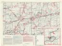
| Description: | This 1975 road map of Columbia County, Wisconsin, shows the location of historic sites in the county but lacks a key to those sites. It includes an inset m... |

| Date: | 1967 |
|---|---|
| Description: | This map of Cedarburg includes a list of historic buildings in the left margin. The map was created by the Ozaukee County Historical Society for Cedarburg'... |

| Date: | 1970 |
|---|---|
| Description: | This photocopy map shows the locations of historic buildings, as well as all other buildings in the isthmus. The map also includes photographs of selected ... |
If you didn't find the material you searched for, our Library Reference Staff can help.
Call our reference desk at 608-264-6535 or email us at:
