Filter: Categories of Wisconsin Historical Images
Filter: Subject of Hills
Filter: Year of 1800-1899
Filter: Categories of Wisconsin Historical Images
Filter: Subject of Hills
Filter: Year of 1800-1899

| Date: | 1832 |
|---|---|
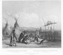
| Description: | Black and white engraving showing landscape with Fort Pierre and Indian tipis along the Missouri River. |
| Date: | 1832 |
|---|---|
| Description: | Funeral of a Sioux Chief near Fort Pierre. |

| Date: | 1886 |
|---|---|
| Description: | Bird's-eye view of Bayfield, county seat of Bayfield County. On the lower left side is an inset for Bayfield and the Apostle Islands. |
| Date: | 1832 |
|---|---|
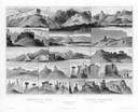
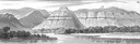
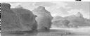
| Description: | Remarkable Hills on the Upper Missouri River (views 10-29). Various scenes of land formations. |
| Date: | 1832 |
|---|---|
| Description: | Remarkable hills on the Upper Missouri River (views 1-9). Various landscapes and rock formations. |
| Date: | 1832 |
|---|---|
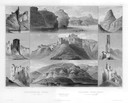
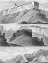
| Description: | Remarkable Hills on Upper Missouri River (view 14). |
| Date: | 1832 |
|---|---|
| Description: | Remarkable hills on the Upper Missouri River (view 1). |
| Date: | 1832 |
|---|---|
| Description: | Remarkable hills on the Upper Missouri River (views 10, 11, and 12) |
| Date: | 1877 |
|---|---|
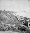
| Description: | View of bluffs and buildings on the shore of Lake Michigan. |
| Date: | 07 1873 |
|---|---|
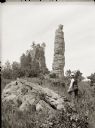
| Description: | Adams and Juneau Counties. Pillar Rock, Fort Danger. There is a man with an 8 x 10 camera in the foreground. |
| Date: | 1886 |
|---|---|
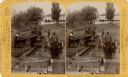
| Description: | Stereograph of men unloading lumber off a raft. A man at the left is loading lumber onto a horse-drawn wagon, while a man in an apron is holding the horses... |
| Date: | 1890 |
|---|---|
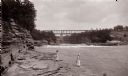
| Description: | Below Kilbourn log dam, 1890s. Two girls are standing on the edge of the river. There is a bridge in the background. |
| Date: | 1853 |
|---|---|
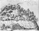
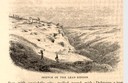
| Description: | Engraved view of miners and hillside mines in the Lead Region. Caption reads: "Sketch of the Lead Region." |
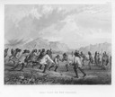
| Date: | 1884 |
|---|---|
| Description: | Native Americans playing a lacrosse-like game of ball. |
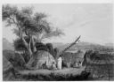
| Date: | 1884 |
|---|---|
| Description: | Indians standing and sitting near wigwams. Four wigwam frames are covered, with the one on the right uncovered, with a campfire inside. In the distance are... |

| Date: | 1897 |
|---|---|
| Description: | A view from the capitol looking west up State Street toward the University of Wisconsin-Madison with the Holy Redeemer Church, Holy Redeemer School, Red Gy... |

| Date: | 1869 |
|---|---|
| Description: | Birds-eye drawing of Boscobel, Grant County, depicts street names and street layouts, houses, rivers and trees. A reference key at the bottom of the map sh... |

| Date: | 1884 |
|---|---|
| Description: | Bird's-eye map of Delavan with inset of the State Institute for Deaf and Dumb. |

| Date: | 1867 |
|---|---|
| Description: | Birds eye drawing of Fond du Lac depicts street names and street layouts, houses, buildings, trees, and the Fond du Lac River. A reference key at the botto... |
If you didn't find the material you searched for, our Library Reference Staff can help.
Call our reference desk at 608-264-6535 or email us at: