 Filter: Categories of Wisconsin Historical Images
Filter: Subject of Hiking
Filter: Subject of service industries
Filter: Categories of Wisconsin Historical Images
Filter: Subject of Hiking
Filter: Subject of service industries

| Date: | 1964 |
|---|---|
| Description: | This 1964 maps shows roads, boat landings and marinas, campgrounds, canoe trails and portages, and lakes and streams in parts of Vilas, Oneida, and Iron co... |
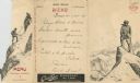
| Date: | 07 03 1908 |
|---|---|
| Description: | Foldout menu from the Hotel Müller, with two men using a pick and line to ascend a mountain on the flap, which opens to reveal the men as they attain the s... |
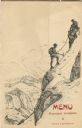
| Date: | 07 03 1908 |
|---|---|
| Description: | Folded menu from the Hotel Müller, with hikers on the die cut flap, ascending a mountain, and mountains and sky on the panel beneath. The drawings are sign... |

| Date: | 1930 |
|---|---|
| Description: | This map shows roads and lakes and includes an inset illustration of Manitowish Waters Fish Hatchery. The back of the map includes a resorts directory, tex... |

| Date: | 1970 |
|---|---|
| Description: | This colored map displays a brief description of tourist attractions in the state, as well as a grid of state parks and recreational facilities. There is a... |

| Date: | 1966 |
|---|---|
| Description: | This colored road map shows automobile roads in Wisconsin as well as portions of nearby states. Information on the quality and type of any road shown (inte... |
If you didn't find the material you searched for, our Library Reference Staff can help.
Call our reference desk at 608-264-6535 or email us at: