 Filter: Categories of Wisconsin Historical Images
Filter: Subject of Hiking
Filter: Subject of lakes
Filter: Categories of Wisconsin Historical Images
Filter: Subject of Hiking
Filter: Subject of lakes

| Date: | 1964 |
|---|---|
| Description: | This 1964 maps shows roads, boat landings and marinas, campgrounds, canoe trails and portages, and lakes and streams in parts of Vilas, Oneida, and Iron co... |
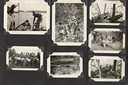
| Date: | |
|---|---|
| Description: | Page from Joy Camps photo album displaying seven photographs. Scenes depicted: canoes and campers on a lake; campers on a wooden footbridge; campers cookin... |

| Date: | 1949 |
|---|---|
| Description: | This map shows points of interest, historic sites, buildings, trails, roads, and general animal and plant locations. |

| Date: | 1930 |
|---|---|
| Description: | This map shows roads and lakes and includes an inset illustration of Manitowish Waters Fish Hatchery. The back of the map includes a resorts directory, tex... |

| Date: | 1935 |
|---|---|
| Description: | A young man wearing a hat, short pants, and a rucksack is standing atop a high rock formation looking down at Devil's Lake. There are wooded bluffs in the ... |
| Date: | 1939 |
|---|---|
| Description: | A young man wearing a cap and sunglasses is posing standing with his right hand resting on a rock formation. He is holding a Kodak Brownie No. 2A box camer... |
If you didn't find the material you searched for, our Library Reference Staff can help.
Call our reference desk at 608-264-6535 or email us at: