 Filter: Categories of Wisconsin Historical Images
Filter: Subject of Hiking
Filter: Subject of human settlements
Filter: Categories of Wisconsin Historical Images
Filter: Subject of Hiking
Filter: Subject of human settlements

| Date: | 1964 |
|---|---|
| Description: | This 1964 maps shows roads, boat landings and marinas, campgrounds, canoe trails and portages, and lakes and streams in parts of Vilas, Oneida, and Iron co... |

| Date: | 1930 |
|---|---|
| Description: | This map shows roads and lakes and includes an inset illustration of Manitowish Waters Fish Hatchery. The back of the map includes a resorts directory, tex... |
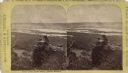
| Date: | |
|---|---|
| Description: | Stereograph of an elevated view of two men posing on Castle Rock. The Mississippi River is below with the city of Winona in the background, and hills are o... |

| Date: | 1960 |
|---|---|
| Description: | A man is running his dog on a trail in an old lead mining area. The trees are bare and fallen leaves are covering the ground. |

| Date: | 02 1962 |
|---|---|
| Description: | Two children breaking a trail through new snow at a park. Trees are in the background and on the right. |
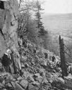
| Date: | 1945 |
|---|---|
| Description: | University students on a field trip to Devil's Lake State Park climb the trail up through the piles of talus (broken rocks) on the slope. A couple in the f... |
If you didn't find the material you searched for, our Library Reference Staff can help.
Call our reference desk at 608-264-6535 or email us at:
