 Filter: Categories of Wisconsin Historical Images
Filter: Subject of Hats
Filter: Subject of science
Filter: Subject of intellectual life
Filter: Categories of Wisconsin Historical Images
Filter: Subject of Hats
Filter: Subject of science
Filter: Subject of intellectual life
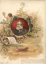
| Date: | 1895 |
|---|---|
| Description: | Color lithograph cover illustration for the McCormick Harvesting Machine Company catalog. Shows a portrait of Cyrus Hall McCormick over an illustration of ... |

| Date: | 1893 |
|---|---|
| Description: | Front and back covers of an advertising brochure for the New Empire line of mowers, reapers and grain binders manufactured by J.F. Seiberling & Company. Th... |

| Date: | |
|---|---|
| Description: | A woman dressed to play golf smiles as a bucket of golf balls is spilled at her feet. This is one of several demonstrations of strobe light functions at F... |
| Date: | 1953 |
|---|---|
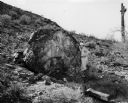
| Description: | Stone displaying ancient writing. The rock was on the grounds of International Harvester's Phoenix Proving Grounds. Opened in 1947, the proving ground was... |

| Date: | 1947 |
|---|---|
| Description: | A man writes information on a chart as he weighs a can of milk in a barn. A row of cows standing in stalls is behind him. The man may be working at Interna... |

| Date: | 1940 |
|---|---|
| Description: | A man inside a building uses a hanging scale to weigh a can of milk. He writes the weight on a chart hanging adjacent to the scale. |

| Date: | 1790 |
|---|---|
| Description: | An updated and corrected version of Robert de Vaugondy's 1750 map "Amérique Septentrionale: Dressée sur les Relations les Plus Modernes des Voyageurs et Na... |

| Date: | 1676 |
|---|---|
| Description: | Detailed map of North and South America. Cities, towns, forests, and mountains are shown pictorially. Duval labels regions, islands, cities, lakes, and Nat... |

| Date: | 1684 |
|---|---|
| Description: | Map of North America showing some colonies, cities, rivers, lakes, and Native American land. Ship routes spread across both oceans, including one decorated... |

| Date: | 1710 |
|---|---|
| Description: | Map of North America showing the European claims, Native American land and villages, rivers, lakes, cities, and notes on explorers, discoveries, and topogr... |

| Date: | 1759 |
|---|---|
| Description: | Map of north eastern Canada and parts of New England, showing settlements, cities, portages, Native American land, mountains, lakes, and rivers. The unusua... |
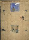
| Date: | 03 15 1896 |
|---|---|
| Description: | Page two of the "Evening Record." The handwritten newspaper includes several hand-drawn illustrations. On the top center of the page, one illustration port... |
If you didn't find the material you searched for, our Library Reference Staff can help.
Call our reference desk at 608-264-6535 or email us at: