 Filter: Categories of Wisconsin Historical Images
Filter: Subject of Hats
Filter: Subject of rivers
Filter: Subject of intellectual life
Filter: Categories of Wisconsin Historical Images
Filter: Subject of Hats
Filter: Subject of rivers
Filter: Subject of intellectual life

| Date: | 1857 |
|---|---|
| Description: | Elevated view of Waukesha with two women wearing dresses with a boy in long pants and tam o'shanter hat in foreground against a split-rail fence. Beyond th... |

| Date: | 1870 |
|---|---|
| Description: | Bird's-eye view of Whitewater, with insets. |

| Date: | 1860 |
|---|---|
| Description: | Bird's-eye view of Janesville from the High School building. |

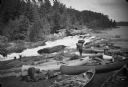
| Date: | |
|---|---|
| Description: | A photographer is setting up for a shot of a man by a river. Across the river are buildings with advertisements and signs. A large log transport is on the ... |

| Date: | 03 10 1902 |
|---|---|
| Description: | Syl, wearing a sailor suit and cap, carves his name into a tree. To the left is a deck suspended over a steep hill. Below is a lake or river. |
| Date: | |
|---|---|
| Description: | View of men and young boys with canoes pulled up on rocks near a rapids during an unidentified wilderness canoe trip led by Sigurd Olson. |

| Date: | |
|---|---|
| Description: | Henry Hamilton Bennett stands with his camera on a platform. He built the platform in order to take photographs of passengers in the boats that toured the ... |

| Date: | 1958 |
|---|---|
| Description: | 26th of July Movement soldiers rest by a river in Oriente Province while on patrol during the Cuban Revolution. They are sitting on a rocky bank of the riv... |

| Date: | 1962 |
|---|---|
| Description: | An American soldier inspects the papers of a Vietnamese man in the countryside along a river. Vietnamese soldiers and a boy are grouped around him. |
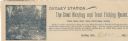
| Date: | |
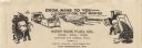
|---|---|
| Description: | Letterhead of Dudley Station, a hunting and trout fishing resort in Dudley, Wisconsin. On the left is an illustration of a fisherman holding a fishing pole... |

| Date: | 1964 |
|---|---|
| Description: | "Mayville photographer, Edgar G. Mueller, covers a parade in Theresa." |
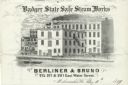
| Date: | |
|---|---|
| Description: | Letterhead of the Berliner & Bruno's Badger State Safe Steam Works of Milwaukee, Wisconsin, with a three-quarter view of the steam works and depot, people ... |

| Date: | |
|---|---|
| Description: | Letterhead of Carl Stargardt, bridge contractor in Athens, Wisconsin, with two-color illustrations in brown and green inks of an automobile heading toward ... |
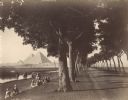
| Date: | 1890 |
|---|---|
| Description: | View down road lined with trees in Egypt. A group of Egyptians are standing and sitting between the trees and the river, and travelers on the road are walk... |
| Date: | |
|---|---|
| Description: | Letterhead of the West Side Fuel Company of Port Washington, Wisconsin, with cartoon-style drawings, printed in black ink, of workers mining coal with a pi... |

| Date: | |
|---|---|
| Description: | Stereograph of H.H. Bennett manning his camera on shore near Steamboat Rock. A woman is in a canoe near the shoreline, and a man is reading a book on the f... |

| Date: | 03 1965 |
|---|---|
| Description: | Keith Brigham is shown checking the U.S. Geological Survey stream gauging station located at the Yahara river locks on Lake Waubesa near McFarland. |

| Date: | 1790 |
|---|---|
| Description: | An updated and corrected version of Robert de Vaugondy's 1750 map "Amérique Septentrionale: Dressée sur les Relations les Plus Modernes des Voyageurs et Na... |

| Date: | 1676 |
|---|---|
| Description: | Detailed map of North and South America. Cities, towns, forests, and mountains are shown pictorially. Duval labels regions, islands, cities, lakes, and Nat... |

| Date: | 1780 |
|---|---|
| Description: | Map of North and South America, showing the boundaries of colonial territories, cities, settlements, rivers, lakes, and Native American land. Particular em... |
If you didn't find the material you searched for, our Library Reference Staff can help.
Call our reference desk at 608-264-6535 or email us at: