 Filter: Categories of Wisconsin Historical Images
Filter: Subject of Harbors
Filter: Categories of Wisconsin Historical Images
Filter: Subject of Harbors
| Date: | |
|---|---|
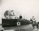
| Description: | Composite photograph in the "Tall Tale" style. An enormous bovine stands on the front deck of the Pere Marquette 21, a steamer. On the right, on the... |

| Date: | 1875 |
|---|---|
| Description: | This map oriented with the north to the upper left is ink, mounted on clothe. The depths of the water are shown by soundings. A handwritten inscription on ... |

| Date: | 1951 |
|---|---|
| Description: | This map is a survey of Lake Michigan and the section of Milwaukee that borders the lake. Map of land includes major streets, and landmarks near water. Rel... |

| Date: | 1910 |
|---|---|
| Description: | In her journal from China, Carrie describes a scene from the harbor: "There are a multitude of boats. The sails are colored like birch. The water under a c... |

| Date: | 1876 |
|---|---|
| Description: | This map shows existing and proposed harbor improvements, streets, the Sauk River, and Lake Michigan. On the bottom of the map inscribed in ink is: "44th C... |

| Date: | |
|---|---|
| Description: | Ships crowded into an icy harbor, possibly in Green Bay. |

| Date: | 1857 |
|---|---|
| Description: | This map was created from a survey made in December 1855 and shows local streets, proposed roads, railroads, the lake shore, bridge wharfs, the basin, the ... |

| Date: | 1898 |
|---|---|
| Description: | This map shows blocks, industrial buildings, and railroads in portions of Duluth and Superior, as well as harbor lines, areas improved, and proposed improv... |

| Date: | 1901 |
|---|---|
| Description: | This map shows streets, industrial buildings, a portion of Lake Superior and other lakes, bays, and rivers in portions of Duluth and Superior. Relief is sh... |

| Date: | 1914 |
|---|---|
| Description: | This map shows streets, industrial buildings, a portion of Lake Superior and other lakes, bays, and rivers in portions of Duluth and Superior. Relief is sh... |

| Date: | 1919 |
|---|---|
| Description: | This map shows details of the harbor, proposed route and bridge changes, railroads, streets, selected buildings, a portion of Lake Superior and other lakes... |
| Date: | 1958 |
|---|---|
| Description: | View from pier of Peterson's Boat Works in Sturgeon Bay. |

| Date: | 1908 |
|---|---|
| Description: | This map shows streets, industrial buildings, a portion of Lake Superior and other lakes, bays, and rivers in portions of Duluth and Superior. Relief is sh... |

| Date: | 1950 |
|---|---|
| Description: | View across street towards several men and women standing in a park with trees and benches. Some of them are taking photographs of the United States Naval ... |
| Date: | 1950 |
|---|---|
| Description: | View across street towards several naval ships in the harbor at the United States Naval Academy. A sign near a lamppost reads: "Santee Basin." |

| Date: | 1900 |
|---|---|
| Description: | This map shows streets, railroads, dock and harbor lines, and parks. The map includes population tables for 1880, 1890, 1900. |

| Date: | 07 25 1967 |
|---|---|
| Description: | Newspaper caption reads: "Passersby don't know it, but what appears to be a coonskin cap around the neck of Todd Vasas, 16, of 2773 S. Shore Drive, is the ... |

| Date: | 06 25 1901 |
|---|---|
| Description: | This map shows beacons, buoys, docks, quarries, streets, and buildings. The map inset shows the Harbor of refuge at entrance to Sturgeon Bay and Lake Michi... |

| Date: | 06 30 1893 |
|---|---|
| Description: | This map shows selected industrial buildings, streets, railroads, docks, and beacons in West Duluth, Duluth, West Superior, and Superior, as well as the St... |

| Date: | 1921 |
|---|---|
| Description: | This map shows Lake Michigan, the Sheboygan River, buildings, streets, churches, industrial yards, and parks. Relief is shown by hachures and depths are sh... |
If you didn't find the material you searched for, our Library Reference Staff can help.
Call our reference desk at 608-264-6535 or email us at: