 Filter: Categories of Wisconsin Historical Images
Filter: Subject of Harbors
Filter: Categories of Wisconsin Historical Images
Filter: Subject of Harbors

| Date: | 1910 |
|---|---|
| Description: | Photographic postcard view across rocky field of dwellings and other buildings along Lake Michigan. Along the left is a rocky ledge. The shoreline of the h... |

| Date: | 1972 |
|---|---|
| Description: | Aerial view of commercial buildings and dwellings along the shore of Lake Michigan. Caption reads: "Baileys Harbor, Wisc." |
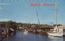
| Date: | |
|---|---|
| Description: | Photographic postcard view from water of a marina. Sailboats and motorboats are docked. More boats are stored up on the shoreline. Trees and buildings are ... |

| Date: | 1921 |
|---|---|
| Description: | This map is part of the survey of the northern and northwestern lakes. The map shows Sheboygan Harbor on the shore of Lake Michigan and the Sheboygan River... |

| Date: | 1909 |
|---|---|
| Description: | This map of Duluth and Superior was issued by the Duluth Street Railway Company and shows street railway routes in the cities, as well as lakes, bays, harb... |

| Date: | 1911 |
|---|---|
| Description: | This map of Duluth and Superior shows street car routes, railroads, ferries, some points of interest, and lighthouses. The bottom left of the map reads: "C... |

| Date: | 1925 |
|---|---|
| Description: | This map of Howard's Bay located at the Duluth Superior Harbor is a close view of Connors Point and shows a key to prevailing winds and water depth measure... |

| Date: | 1964 |
|---|---|
| Description: | This map of Two Rivers shows the Rodgers street fishing area and land use. The map features a legend on the right of the types of land use. The map also sh... |

| Date: | 1951 |
|---|---|
| Description: | This map shows Ashland and Washburn harbors in shades of blue and yellow. Water depths shown by isolines and soundings, and relief is shown by contours. Th... |

| Date: | 1892 |
|---|---|
| Description: | This map of Bayfield shows roads, lots, and township boundaries. The map was originally published on one sheet but is now separated into front and back. On... |
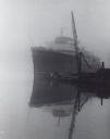
| Date: | 10 1962 |
|---|---|
| Description: | Lake steamer at dock, in fog. To the right is the boom of a crane. In front of the steamer is a tugboat. |

| Date: | 1951 |
|---|---|
| Description: | This map of Racine Harbor has relief shown by contours and depths shown by gradient tints and soundings in feet. The map also shows Racine Reef, Wind Point... |

| Date: | 1970 |
|---|---|
| Description: | This map is intended for tourists of La Crosse. The cover features images of farms and natural land and reads: "friends are but strangers... we have yet to... |

| Date: | 1941 |
|---|---|
| Description: | Elevated view of Sturgeon Bay in 1900. Sturgeon Bay Bridge spans the bay and several boats are on the water. A lighthouse sits on a small island in the bay... |

| Date: | 1961 |
|---|---|
| Description: | This map shows established harbor lines, local streets, railroads, U.S. government channel, and part of Fox River. The map includes a table of reference po... |

| Date: | 1855 |
|---|---|
| Description: | This map has relief shown by hachures and soundings and shows local streets, proposed roads, railroads, bridge wharfs, basin, north arm, and west arm of Ke... |

| Date: | |
|---|---|
| Description: | Exterior of the menu for Paul's Cafe, with a bird's-eye view map of "Washburn's Natural Deep Water Land Locked Harbor," Chequamegon Bay, and the Apostle Is... |

| Date: | 1900 |
|---|---|
| Description: | This map is pencil and ink on tracing cloth and shows local streets, railroads, harbor line, and part of Chequamegon Bay. |

| Date: | 1896 |
|---|---|
| Description: | Catalog cover of Adriance, Platt & Co. features an illustration of a farmer standing in a field holding a scythe and wiping his brow. In the background men... |
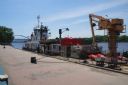
| Date: | 2012 |
|---|---|
| Description: | United States Coast Guard boat and a dredging barge at the Riverside Park, Levee Dock, a United States port facility on the Mississippi River. A brick walk... |
If you didn't find the material you searched for, our Library Reference Staff can help.
Call our reference desk at 608-264-6535 or email us at: