 Filter: Categories of Wisconsin Historical Images
Filter: Subject of Harbors
Filter: Year of 1900-1999
Filter: Categories of Wisconsin Historical Images
Filter: Subject of Harbors
Filter: Year of 1900-1999
| Date: | 1920 |
|---|---|
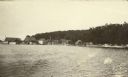
| Description: | View from the water of Washington Harbor on Washington Island. There are boats moored and warehouses along the pier. Fishing nets dry on racks on the shore... |
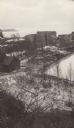
| Date: | 02 11 1925 |
|---|---|
| Description: | View of the large abandoned furnace complex, left, company store, far right, and blacksmith shop behind the company store, on the site of the Jackson Iron ... |
| Date: | 02 1925 |
|---|---|
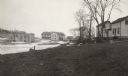
| Description: | There is smoke damage to the bricks evident above the windows of the company store in this view of the ghost town of Fayette. To the right, with dormers, i... |
| Date: | 02 1925 |
|---|---|
| Description: | An unidentified man looks across Snail Shell Harbor at the remains of the Jackson Iron Company works. The large furnace complex is visible through the tree... |
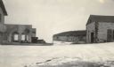
| Date: | 02 1925 |
|---|---|
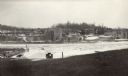
| Description: | Elevated view of the abandoned town of Fayette. Snail Shell Harbor is in the foreground, with a low warehouse along the boat dock and empty buildings on th... |
| Date: | 02 1925 |
|---|---|
| Description: | Elevated view of the abandoned Jackson Iron Company furnace complex at Fayette, on the shore of Snail Shell Harbor. Lake Michigan is in the background. |
| Date: | 02 1925 |
|---|---|
| Description: | Dolomite cliffs along Snail Shell Harbor are seen in the background between the ruined buildings of the company store, left, and the machine shop on the gr... |

| Date: | 1935 |
|---|---|
| Description: | An International C-55 truck works to build a breakwater at Port Allen on the island of Kauai. |

| Date: | 1916 |
|---|---|
| Description: | This Wisconsin Conservation Commission map from 1916 shows Peninsula State Park in the Town of Gibraltar, Door County, Wisconsin. Depicted are open and pla... |

| Date: | 1916 |
|---|---|
| Description: | This version of a 1916 Wisconsin Conservation Commission map shows Peninsula State Park in the Town of Gibraltar, Door County, Wisconsin. Depicted are open... |
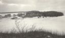
| Date: | 1915 |
|---|---|
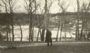
| Description: | Winter scene from Egg Harbor Road (Highway 42) in Fish Creek looking north toward frozen Fish Creek Harbor with the bluffs in Peninsula State Park beyond. ... |

| Date: | 1909 |
|---|---|
| Description: | This 1909 chart of the Apostle Islands, Chequamegon Bay, and the Lake Superior shoreline shows relief by contours and spot heights and depths by contours, ... |

| Date: | 1900 |
|---|---|
| Description: | This chart of the northern Apostle Islands and Lake Superior shoreline shows relief by contours and spot heights and depths by contours, gradient tints and... |

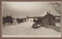
| Date: | 1913 |
|---|---|
| Description: | Two of the photographer's children, Margaret (Sissy), left, and Ferdinand Leonard (Fedy), right, on Weborg Point. Fish Creek Harbor is in the background; t... |

| Date: | 1915 |
|---|---|
| Description: | Elevated view over a heavily wooded area to Fish Creek Harbor and Hen Island, with Peninsula State Park in the background. |
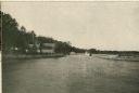
| Date: | 1915 |
|---|---|
| Description: | View from shoreline over water towards a three-masted sailing vessel docked at Baileys Harbor pier. Houses and commercial buildings line the shore. |

| Date: | 05 1958 |
|---|---|
| Description: | Photocopy of a map created by the City of Milwaukee Master Plan Program City Planning Division in May of 1958 representing 1870 "THE CENTRAL AREA OF THE CI... |

| Date: | 02 05 1944 |
|---|---|
| Description: | General view of Port Moresby Harbor from road, New Guinea (present day Papua New Guinea). A jeep is on the road on the left. Several soldiers are near a sh... |
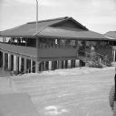
| Date: | 02 05 1944 |
|---|---|
| Description: | View from road of the exterior of the Allied Officers' Club in Port Moresby, New Guinea (present day Papua New Guinea). It is built on posts above the wate... |
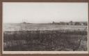
| Date: | 1910 |
|---|---|
| Description: | View of the harbor at Waldwic on Lake Buttes des Morts. |
If you didn't find the material you searched for, our Library Reference Staff can help.
Call our reference desk at 608-264-6535 or email us at: