 Filter: Categories of Wisconsin Historical Images
Filter: Subject of Harbors
Filter: Year of 1800-1899
Filter: Year of 1880-1889
Filter: Categories of Wisconsin Historical Images
Filter: Subject of Harbors
Filter: Year of 1800-1899
Filter: Year of 1880-1889

| Date: | 1886 |
|---|---|
| Description: | Bird's-eye view of Ashland, on the shores of Lake Superior, with insets of The Apostle Islands Chequamagon Bay & Ashland, and Distances from Ashland. |
| Date: | 1888 |
|---|---|
| Description: | Elevated view of men repairing a docked, damaged ship. A shoreline is in the distance. |

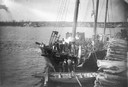
| Date: | 1880 |
|---|---|
| Description: | Bird's-eye map of Sturgeon Bay. County Seat of Door County. |

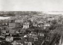
| Date: | 1886 |
|---|---|
| Description: | Bird's-eye view of Milwaukee from Bay View. |
| Date: | 1889 |
|---|---|
| Description: | Elevated view looking north toward the harbor with multiple buildings in the foreground. |
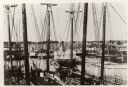
| Date: | 1887 |
|---|---|
| Description: | Some of the Old-Timers in the photograph: Steamers: Petosky (on stocks), Muskegon, Corona, A.D. Hayward, City of St. Joe, Lotus, J.F. Dayan, Grace Willia... |

| Date: | 1880 |
|---|---|
| Description: | Map of Wisconsin including the eastern portions on Minnesota, Iowa, northern Illinois, and the western most portion of Michigan’s Upper Peninsula, showing ... |
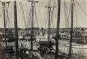
| Date: | 1887 |
|---|---|
| Description: | Caption reads: "Some of the Old-Timers on the Photo. Steamers: Petosky (on stocks), Muskegon, Corona, A.D. Hayward, City of St. Joe, Lotus, J.F. Dayan, Gra... |
If you didn't find the material you searched for, our Library Reference Staff can help.
Call our reference desk at 608-264-6535 or email us at:
