 Filter: Categories of Wisconsin Historical Images
Filter: Subject of Harbors
Filter: Year of 1800-1899
Filter: Categories of Wisconsin Historical Images
Filter: Subject of Harbors
Filter: Year of 1800-1899

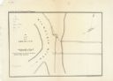
| Date: | 1867 |
|---|---|
| Description: | This map shows components of the bottom of Lake Michigan and the Root River, as well as the harbor, buildings, streets, railroads, and rural landowners in ... |

| Date: | 07 19 1854 |
|---|---|
| Description: | This map shows the shore in 1844, 1850, and 1852, the length of and proposed additions to the pier. Relief is shown by hachures and depths are shown by sou... |

| Date: | 07 19 1854 |
|---|---|
| Description: | This hand-colored map shows the North and South Pier, the North Pier Bridge, the present Channel, and the Channel to be dredged. Lake Michigan and a light ... |

| Date: | 1857 |
|---|---|
| Description: | This map with north oriented toward the lower left shows the United States North and South Piers. Lake shores from 1855, 1856, and 1857 are labeled. Depths... |

| Date: | 09 1853 |
|---|---|
| Description: | This map shows streets, docks, warehouses, and piers near the harbor. The Manitowoc River and Lake Michigan are labeled. Depths are indicated by soundings ... |

| Date: | 1854 |
|---|---|
| Description: | This map shows streets, docks, warehouses, and piers near the harbor. Relief is shown by hachures and depths are shown by soundings and isolines. Lake Mich... |

| Date: | 1856 |
|---|---|
| Description: | This map shows streets, piers, and wharves. Lake Michigan, the Manitowoc River, and select buildings are labeled. Relief is shown by hachures and sounding... |

| Date: | 1865 |
|---|---|
| Description: | This map shows the river shore and piers. Lake Michigan is labeled. Depths are shown by soundings and isolines. The bottom margin includes notes on soundi... |

| Date: | 1874 |
|---|---|
| Description: | This map shows piers, streets, the Manitowoc River and shore lines of 1856, 1869, 1873 and 1874. The top margin reads; "Soundings taken 1974." Written in i... |

| Date: | 1854 |
|---|---|
| Description: | This map shows bay and harbor soundings, the Milwaukee River, and select buildings. Depths are shown by soundings and relief is shown by hachures. The top ... |
| Date: | 1854 |
|---|---|
| Description: | This map is oriented with north slightly to the right and the Milwaukee River is labeled. The top margin reads: "Senate Ex. Doc. No. 1. 1st Session, 33rd C... |

| Date: | 10 13 1864 |
|---|---|
| Description: | This map shows the shore line of Oct. 14 1864, city limits of water lots, and the elevation of water in Lake Michigan. Depths are shown by soundings. |

| Date: | 10 1853 |
|---|---|
| Description: | This map shows warehouses and proposed extensions of piers. "Note: The soundings are in feet and tenths." The upper left margin reads: "Senate Ex. Doc. No.... |

| Date: | 10 1853 |
|---|---|
| Description: | This map shows warehouses and proposed extensions of piers. Also included are notes on soundings and the proposed extensions. The upper right margin reads:... |

| Date: | 1865 |
|---|---|
| Description: | This map shows a proposed extension and the shore line of Sept. ’65. Lake Michigan is labeled. Depths are shown by soundings. |

| Date: | 1865 |
|---|---|
| Description: | This map shows the harbor with proposed extensions and the shore line as it appeared in 1865. Depths are shown by soundings. |

| Date: | 1857 |
|---|---|
| Description: | This map shows piers, wharves, streets, and the lake shore from the survey of August 1856. Lake Michigan and the Sheboygan River are labeled. Depths are sh... |

| Date: | 1831 |
|---|---|
| Description: | This map shows the land that makes up Michigan, Wisconsin, Minnesota, Indiana, and parts of Canada. The Great Lakes are displayed prominently, along with s... |
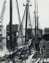
| Date: | 1875 |
|---|---|
| Description: | Elevated view of a deck of a schooner hauling lumber. Several workmen are loading or unloading the lumber. Industrial buildings, some displaying signs, are... |

| Date: | 1873 |
|---|---|
| Description: | This blueprint map shows water depths by soundings and isolines. To the top left is Duluth, Minnesota. To the bottom right is Superior City, Wisconsin. The... |
If you didn't find the material you searched for, our Library Reference Staff can help.
Call our reference desk at 608-264-6535 or email us at: