 Filter: Categories of Wisconsin Historical Images
Filter: Subject of Harbors
Filter: Year of 1800-1899
Filter: Subject of michigan, lake
Filter: Categories of Wisconsin Historical Images
Filter: Subject of Harbors
Filter: Year of 1800-1899
Filter: Subject of michigan, lake

| Date: | 1862 |
|---|---|
| Description: | Drawn the second year of the Civil War, this 1862 map of Milwaukee shows post offices, light houses, beacon lights, county buildings, elevator warehouses, ... |
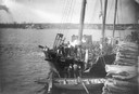
| Date: | 1888 |
|---|---|
| Description: | Elevated view of men repairing a docked, damaged ship. A shoreline is in the distance. |

| Date: | 1857 |
|---|---|
| Description: | From Judge Smith Addition, 5th Ward, looking north, toward the city. Drawing is an elevated view of field and plank fence in foreground, road to the left a... |

| Date: | 1886 |
|---|---|
| Description: | Bird's-eye view of Milwaukee from Bay View. |

| Date: | 1892 |
|---|---|
| Description: | Bird's-eye view of Chicago, with ships in the Lake Michigan harbor. |
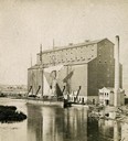
| Date: | 1870 |
|---|---|
| Description: | The Milwaukee & St. Paul Railway Company grain elevator at the Milwaukee harbor, with a sailing ship anchored nearby. |

| Date: | 05 15 1897 |
|---|---|
| Description: | Elevated view of the Chicago & Northwestern Railway yards looking northwest. The elevator of the Northern Grain Company is in the middle distance. |

| Date: | 1892 |
|---|---|
| Description: | Bird's-eye view of the Columbian Exposition pavilions from the vantage point of Lake Michigan. Included is an inset of the Union Passenger Station (now Uni... |
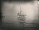
| Date: | 1890 |
|---|---|
| Description: | Schooner coming into Manitowoc harbor. |

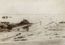
| Date: | 1875 |
|---|---|
| Description: | The harbor piers and the entrance to the Sturgeon Bay ship canal. Men are standing on the shoreline. |

| Date: | 1876 |
|---|---|
| Description: | Made from U.S. Surveys and from minutes furnished by Jos. S. Buck and Dr. C. Chase. Scale 20 CHs to an inch. |
| Date: | 1895 |
|---|---|
| Description: | View from across railroad tracks. Resort is on the water's edge, with a small inlet on the right. Land is mostly sand, though a small part on the left ha... |
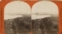
| Date: | 1876 |
|---|---|
| Description: | Stereograph. Elevated view looking roughly south, the foreground overlooks a residential neighborhood. On the far shoreline, smoke clouds spew out from lar... |
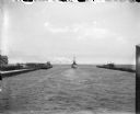
| Date: | 07 1899 |
|---|---|
| Description: | A boat leaving Milwaukee Harbor between two breakwaters, steaming into Milwaukee Bay and onward out into Lake Michigan. |
| Date: | 1898 |
|---|---|
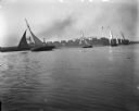
| Description: | Small sailboats in Milwaukee Harbor with buildings on the far shoreline in the background. There is a large sign on a roof that readsin part: "L.J. Petit..... |
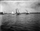
| Date: | 1898 |
|---|---|
| Description: | Four sailboats in Milwaukee Harbor, one of which, The Kim, has Syl on board. In the background are railroad cars and industrial buildings. |
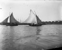
| Date: | 1898 |
|---|---|
| Description: | View across water of sailboats in Milwaukee Bay. One of the boats, The Kim, has Syl on board. In the background are industrial buildings, one of whi... |
| Date: | 1898 |
|---|---|
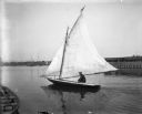
| Description: | Pennyfeather sitting in a small sailboat in Milwaukee Harbor. There are industrial buildings on the far shoreline, and other boats at anchor in the backgro... |

| Date: | 1880 |
|---|---|
| Description: | Map of Wisconsin including the eastern portions on Minnesota, Iowa, northern Illinois, and the western most portion of Michigan’s Upper Peninsula, showing ... |
If you didn't find the material you searched for, our Library Reference Staff can help.
Call our reference desk at 608-264-6535 or email us at:
