 Filter: Categories of Wisconsin Historical Images
Filter: Subject of Harbors
Filter: Year of 1800-1899
Filter: Creator Name of Unknown
Filter: Categories of Wisconsin Historical Images
Filter: Subject of Harbors
Filter: Year of 1800-1899
Filter: Creator Name of Unknown

| Date: | 1873 |
|---|---|
| Description: | The harbor, showing the sidewheel packet, "Belle of La Crosse," and the sidewheel ferry "Alex McGregor." Other boats are also seen including two barges loa... |

| Date: | 1862 |
|---|---|
| Description: | Drawn the second year of the Civil War, this 1862 map of Milwaukee shows post offices, light houses, beacon lights, county buildings, elevator warehouses, ... |

| Date: | 05 15 1897 |
|---|---|
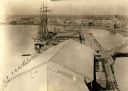
| Description: | Elevated view of the Chicago & Northwestern Railway yards looking northwest. The elevator of the Northern Grain Company is in the middle distance. |
| Date: | 1850 |
|---|---|
| Description: | Elevated view of the Green Bay harbor and docks. |

| Date: | 1875 |
|---|---|
| Description: | The harbor piers and the entrance to the Sturgeon Bay ship canal. Men are standing on the shoreline. |
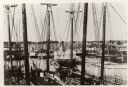
| Date: | 1887 |
|---|---|
| Description: | Some of the Old-Timers in the photograph: Steamers: Petosky (on stocks), Muskegon, Corona, A.D. Hayward, City of St. Joe, Lotus, J.F. Dayan, Grace Willia... |

| Date: | 1857 |
|---|---|
| Description: | This map of Sheboygan Harbor shows the river mouth and harbor, piers, wharfs, piles of old destroyed bridge wharfs, streets, and the lake shore from survey... |

| Date: | 1836 |
|---|---|
| Description: | This map is pen-and-ink on paper and shows marshlands, rivers, creeks, a quarry, and a few roads. |

| Date: | 09 1853 |
|---|---|
| Description: | This map shows streets, docks, warehouses, and piers near the harbor. The Manitowoc River and Lake Michigan are labeled. Depths are indicated by soundings ... |

| Date: | 1856 |
|---|---|
| Description: | This map shows streets, piers, and wharves. Lake Michigan, the Manitowoc River, and select buildings are labeled. Relief is shown by hachures and sounding... |

| Date: | 1865 |
|---|---|
| Description: | This map shows the river shore and piers. Lake Michigan is labeled. Depths are shown by soundings and isolines. The bottom margin includes notes on soundi... |

| Date: | 1874 |
|---|---|
| Description: | This map shows piers, streets, the Manitowoc River and shore lines of 1856, 1869, 1873 and 1874. The top margin reads; "Soundings taken 1974." Written in i... |

| Date: | 10 13 1864 |
|---|---|
| Description: | This map shows the shore line of Oct. 14 1864, city limits of water lots, and the elevation of water in Lake Michigan. Depths are shown by soundings. |

| Date: | 10 1853 |
|---|---|
| Description: | This map shows warehouses and proposed extensions of piers. "Note: The soundings are in feet and tenths." The upper left margin reads: "Senate Ex. Doc. No.... |

| Date: | 10 1853 |
|---|---|
| Description: | This map shows warehouses and proposed extensions of piers. Also included are notes on soundings and the proposed extensions. The upper right margin reads:... |

| Date: | 1865 |
|---|---|
| Description: | This map shows a proposed extension and the shore line of Sept. ’65. Lake Michigan is labeled. Depths are shown by soundings. |

| Date: | 1865 |
|---|---|
| Description: | This map shows the harbor with proposed extensions and the shore line as it appeared in 1865. Depths are shown by soundings. |

| Date: | 1857 |
|---|---|
| Description: | This map shows piers, wharves, streets, and the lake shore from the survey of August 1856. Lake Michigan and the Sheboygan River are labeled. Depths are sh... |
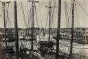
| Date: | 1887 |
|---|---|
| Description: | Caption reads: "Some of the Old-Timers on the Photo. Steamers: Petosky (on stocks), Muskegon, Corona, A.D. Hayward, City of St. Joe, Lotus, J.F. Dayan, Gra... |
If you didn't find the material you searched for, our Library Reference Staff can help.
Call our reference desk at 608-264-6535 or email us at:
