 Filter: Categories of Wisconsin Historical Images
Filter: Subject of Harbors
Filter: Subject of trees
Filter: Subject of church buildings
Filter: Categories of Wisconsin Historical Images
Filter: Subject of Harbors
Filter: Subject of trees
Filter: Subject of church buildings

| Date: | 1857 |
|---|---|
| Description: | From Judge Smith Addition, 5th Ward, looking north, toward the city. Drawing is an elevated view of field and plank fence in foreground, road to the left a... |

| Date: | |
|---|---|
| Description: | Elevated view of village homes on the shores of the bay with docked fishing boats in the foreground. Caption reads, "Marblehead, Mass from Rockmere Point." |
| Date: | |
|---|---|
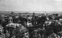
| Description: | Elevated view looking down on the town with the bay and opposite shoreline in distance. |
| Date: | |
|---|---|
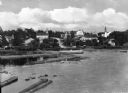
| Description: | View of Eagle Harbor and the area surrounding Church Street. On the right, Ephraim Moravian Church, completed in 1859, can be seen among residential buildi... |
| Date: | |
|---|---|
| Description: | View of waterfront and city buildings from across the harbor. Rock Church stands near the shore. |
| Date: | 02 1924 |
|---|---|
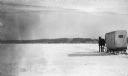
| Description: | A single horse pulls an enclosed sleigh across a frozen Door County harbor. Houses and a church are visible onshore. |
| Date: | 1924 |
|---|---|
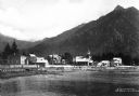
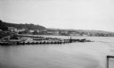
| Description: | Elevated view over water of the harbor and buildings of Frankfort. There is a deteriorating pier in the foreground. |
If you didn't find the material you searched for, our Library Reference Staff can help.
Call our reference desk at 608-264-6535 or email us at:
