 Filter: Categories of Wisconsin Historical Images
Filter: Subject of Harbors
Filter: Subject of streets
Filter: Categories of Wisconsin Historical Images
Filter: Subject of Harbors
Filter: Subject of streets
| Date: | |
|---|---|
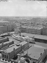
| Description: | Elevated view of Milwaukee, looking southwest from Mitchell block showing buildings, and the paddle steamer John A. Dix. |

| Date: | 1910 |
|---|---|
| Description: | Bird's-eye view looking east, with Washburn Harbor at center and Chequamegon Bay in Lake Superior covering most of the upper image. Streets with buildings... |

| Date: | 1892 |
|---|---|
| Description: | Bird's-eye view of Chicago, with ships in the Lake Michigan harbor. |
| Date: | |
|---|---|
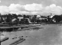
| Description: | View of Eagle Harbor and the area surrounding Church Street. On the right, Ephraim Moravian Church, completed in 1859, can be seen among residential buildi... |

| Date: | |
|---|---|
| Description: | Bird's-eye view lithograph of Key West with ships and smaller boats in the surrounding waters. |

| Date: | |
|---|---|
| Description: | Elevated view down Beach Boulevard, a boardwalk-like street with gift shops and carnival events facing the beach and harbor. Crowds of people are on the si... |

| Date: | |
|---|---|
| Description: | Elevated general view of the city with harbor and mountains. A ship is docked near the railroad bridge. |

| Date: | |
|---|---|
| Description: | View from Cole's Hill of the Plymouth Rock Monument, a granite canopy built in 1920 to house the Plymouth Rock. The inscription reads, "Erected by the Nat... |

| Date: | 1857 |
|---|---|
| Description: | This map of Sheboygan Harbor shows the river mouth and harbor, piers, wharfs, piles of old destroyed bridge wharfs, streets, and the lake shore from survey... |

| Date: | 1848 |
|---|---|
| Description: | Pen-and-ink on paper. The title of the map is inscribed on the back. The map shows buildings, roads, marshes, wild rice, piles and docks, deep water, and o... |

| Date: | 1918 |
|---|---|
| Description: | Elevated view looking down gutter of roof towards the British volunteer forces parading in Archangel [Archangelsk], Russia right before they disembarked fr... |

| Date: | 1918 |
|---|---|
| Description: | Elevated view from roof of British volunteer forces parading in Archangel [Archangelsk], Russia right before they disembarked from the town. The crowd watc... |

| Date: | 1972 |
|---|---|
| Description: | Aerial view of commercial buildings and dwellings along the shore of Lake Michigan. Caption reads: "Baileys Harbor, Wisc." |

| Date: | 1921 |
|---|---|
| Description: | This map is part of the survey of the northern and northwestern lakes. The map shows Sheboygan Harbor on the shore of Lake Michigan and the Sheboygan River... |

| Date: | 1951 |
|---|---|
| Description: | This map of Racine Harbor has relief shown by contours and depths shown by gradient tints and soundings in feet. The map also shows Racine Reef, Wind Point... |

| Date: | 1970 |
|---|---|
| Description: | This map is intended for tourists of La Crosse. The cover features images of farms and natural land and reads: "friends are but strangers... we have yet to... |

| Date: | 1961 |
|---|---|
| Description: | This map shows established harbor lines, local streets, railroads, U.S. government channel, and part of Fox River. The map includes a table of reference po... |

| Date: | 1900 |
|---|---|
| Description: | This map is pencil and ink on tracing cloth and shows local streets, railroads, harbor line, and part of Chequamegon Bay. |

| Date: | 1951 |
|---|---|
| Description: | This map is a survey of Lake Michigan and the section of Milwaukee that borders the lake. Map of land includes major streets, and landmarks near water. Rel... |

| Date: | 1876 |
|---|---|
| Description: | This map shows existing and proposed harbor improvements, streets, the Sauk River, and Lake Michigan. On the bottom of the map inscribed in ink is: "44th C... |
If you didn't find the material you searched for, our Library Reference Staff can help.
Call our reference desk at 608-264-6535 or email us at: