Filter: Categories of Wisconsin Historical Images
Filter: Subject of Harbors
Filter: Subject of roads
Filter: Subject of cities and towns
Filter: Categories of Wisconsin Historical Images
Filter: Subject of Harbors
Filter: Subject of roads
Filter: Subject of cities and towns

| Date: | 1886 |
|---|---|
| Description: | Bird's-eye view of Ashland, on the shores of Lake Superior, with insets of The Apostle Islands Chequamagon Bay & Ashland, and Distances from Ashland. |

| Date: | 1913 |
|---|---|
| Description: | Bird's-eye map of Superior. "The New Steel Center." |

| Date: | 1857 |
|---|---|
| Description: | From Judge Smith Addition, 5th Ward, looking north, toward the city. Drawing is an elevated view of field and plank fence in foreground, road to the left a... |

| Date: | 05 15 1897 |
|---|---|
| Description: | Elevated view of the Chicago & Northwestern Railway yards looking northwest. The elevator of the Northern Grain Company is in the middle distance. |
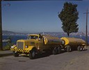
| Date: | 1951 |
|---|---|
| Description: | Color photograph of an International LD-400 series tanker truck owned by Eastern Washington Transports, Inc., on a road near the Port of Seattle. |
| Date: | |
|---|---|
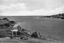
| Description: | Eagle Harbor, looking west, with boats anchored in the harbor. In the foreground are the stone pillars of the village fire station. |
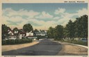
| Date: | 1951 |
|---|---|
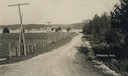
| Description: | View down road curving towards Ephraim. Trees are along a lawn on the right near water. Caption reads: "Ephraim, Wisconsin". |
| Date: | 1905 |
|---|---|
| Description: | A lane in Ephraim with power lines lining the road. There is a body of water in the distance with houses on the far shoreline. |
| Date: | 1940 |
|---|---|
| Description: | View from hill of the yacht club, with Lake Michigan behind. In the distance is the jetty, and the road along the shoreline is N. Lincoln Memorial Drive. T... |

| Date: | 1953 |
|---|---|
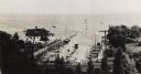
| Description: | Aerial view looking north from the foot of Milwaukee's main thoroughfare, Wisconsin Avenue. Lincoln Memorial Drive winds its way along the lagoon in Juneau... |
| Date: | 1900 |
|---|---|
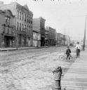
| Description: | Syl stands holding an umbrella near an unidentified boy who is leaning on a bicycle on the edge of a cobblestone street. Storefronts are along the street o... |

| Date: | |
|---|---|
| Description: | An aerial view of the port and a section of the city showing a large boat, a railway depot, a park plaza and a grid of city streets with large buildings. |

| Date: | |
|---|---|
| Description: | Aerial view of a developed strip of land on Barnegat Bay showing the Atlantic ocean, houses, lakes, railroad tracks, a marina and a jetty in the distance. |

| Date: | 1880 |
|---|---|
| Description: | Map of Wisconsin including the eastern portions on Minnesota, Iowa, northern Illinois, and the western most portion of Michigan’s Upper Peninsula, showing ... |
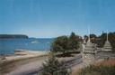
| Date: | 1925 |
|---|---|
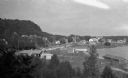
| Description: | Elevated view of Fish Creek from the east; the bluff rises on the left, the harbor is on the right. The cottage in the foreground with pergola and lattice ... |

| Date: | 05 1958 |
|---|---|
| Description: | Photocopy of a map created by the City of Milwaukee Master Plan Program City Planning Division in May of 1958 representing 1870 "THE CENTRAL AREA OF THE CI... |

| Date: | 1892 |
|---|---|
| Description: | This map of Bayfield shows roads, lots, and township boundaries. The map was originally published on one sheet but is now separated into front and back. On... |
If you didn't find the material you searched for, our Library Reference Staff can help.
Call our reference desk at 608-264-6535 or email us at: