 Filter: Categories of Wisconsin Historical Images
Filter: Subject of Harbors
Filter: Subject of roads
Filter: Subject of bridges
Filter: Categories of Wisconsin Historical Images
Filter: Subject of Harbors
Filter: Subject of roads
Filter: Subject of bridges

| Date: | 05 15 1897 |
|---|---|
| Description: | Elevated view of the Chicago & Northwestern Railway yards looking northwest. The elevator of the Northern Grain Company is in the middle distance. |

| Date: | 1941 |
|---|---|
| Description: | Elevated view of Sturgeon Bay in 1900. Sturgeon Bay Bridge spans the bay and several boats are on the water. A lighthouse sits on a small island in the bay... |

| Date: | 1855 |
|---|---|
| Description: | This map has relief shown by hachures and soundings and shows local streets, proposed roads, railroads, bridge wharfs, basin, north arm, and west arm of Ke... |

| Date: | |
|---|---|
| Description: | Aerial view of harbors and bridge. Farm fields are on either side of the bridge. The city of Sturgeon Bay is in the distance. There are docks along the sho... |

| Date: | 11 1781 |
|---|---|
| Description: | Map of New York, Staten Island, and Long Island, showing the placements of forts, and the movement of troops in 1776. The map also includes towns, cities, ... |
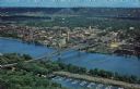
| Date: | |
|---|---|
| Description: | Photographic postcard of an aerial view over La Crosse and the I-90 Interstate bridge. French Island is in the foreground. |
If you didn't find the material you searched for, our Library Reference Staff can help.
Call our reference desk at 608-264-6535 or email us at:
