Filter: Categories of Wisconsin Historical Images
Filter: Subject of Harbors
Filter: Subject of rivers
Filter: Categories of Wisconsin Historical Images
Filter: Subject of Harbors
Filter: Subject of rivers

| Date: | 1862 |
|---|---|
| Description: | Drawn the second year of the Civil War, this 1862 map of Milwaukee shows post offices, light houses, beacon lights, county buildings, elevator warehouses, ... |
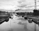
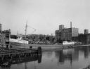
| Date: | 1945 |
|---|---|
| Description: | Harbor in Marinette at sunset. Boats are docked at the sides of a canal. Smoke pours from smokestacks of a facility in the distance. |
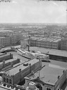
| Date: | |
|---|---|
| Description: | Elevated view of Milwaukee, looking southwest from Mitchell block showing buildings, and the paddle steamer John A. Dix. |

| Date: | 1913 |
|---|---|
| Description: | Bird's-eye map of Superior. "The New Steel Center." |

| Date: | 1886 |
|---|---|
| Description: | Bird's-eye view of Milwaukee from Bay View. |

| Date: | 1892 |
|---|---|
| Description: | Bird's-eye view of Chicago, with ships in the Lake Michigan harbor. |

| Date: | 1892 |
|---|---|
| Description: | Bird's-eye view of the Columbian Exposition pavilions from the vantage point of Lake Michigan. Included is an inset of the Union Passenger Station (now Uni... |
| Date: | 1900 |
|---|---|
| Description: | Looking North. Harbor with boats, bridge, and buildings. |
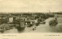
| Date: | 1900 |
|---|---|
| Description: | Elevated view of east Green Bay harbor with cargo ships, W.W. Cagill Co., and other various industries. |
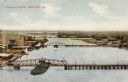
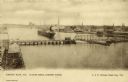
| Date: | 1910 |
|---|---|
| Description: | Elevated view of the harbor entrance. Caption reads: "Harbor Entrance, Green Bay, Wis." |
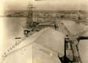
| Date: | 1850 |
|---|---|
| Description: | Elevated view of the Green Bay harbor and docks. |

| Date: | 1876 |
|---|---|
| Description: | Made from U.S. Surveys and from minutes furnished by Jos. S. Buck and Dr. C. Chase. Scale 20 CHs to an inch. |

| Date: | 1853 |
|---|---|
| Description: | Plan no. 3. Scale 2000 feet to one inch. |
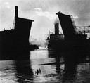
| Date: | 03 19 1940 |
|---|---|
| Description: | View across Milwaukee River of workers of the Herman M. Hettler Lumber Company unloading lumber off a shipping boat to the Shroeder Lumber Yards and Troste... |
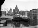
| Date: | |
|---|---|
| Description: | Elevated view of two Goodrich Line passenger ferries docked on the west bank of the Milwaukee River, north of the Clybourn Street bridge. The Pabst buildin... |
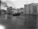
| Date: | |
|---|---|
| Description: | Looking north on the Milwaukee River as the whaleback excursion steamer "Christopher Columbus" is guided by tugboats at about St. Paul Avenue. |
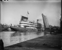
| Date: | 08 30 1906 |
|---|---|
| Description: | The excursion steamer "Christopher Columbus" passing through the Broadway Bridge in Milwaukee, Wisconsin. Caption on glass plate reads, "Steamer, Christoph... |
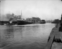
| Date: | |
|---|---|
| Description: | Steamboat "Thomas Mattham" in the Milwaukee harbor being pulled by a tugboat from the north bank near Erie Street. |
If you didn't find the material you searched for, our Library Reference Staff can help.
Call our reference desk at 608-264-6535 or email us at: