 Filter: Categories of Wisconsin Historical Images
Filter: Subject of Harbors
Filter: Subject of rivers
Filter: Subject of ferries
Filter: Categories of Wisconsin Historical Images
Filter: Subject of Harbors
Filter: Subject of rivers
Filter: Subject of ferries
| Date: | |
|---|---|
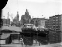
| Description: | Elevated view of two Goodrich Line passenger ferries docked on the west bank of the Milwaukee River, north of the Clybourn Street bridge. The Pabst buildin... |
| Date: | |
|---|---|
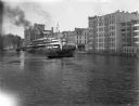
| Description: | Looking north on the Milwaukee River as the whaleback excursion steamer "Christopher Columbus" is guided by tugboats at about St. Paul Avenue. |

| Date: | 11 1781 |
|---|---|
| Description: | Map of New York, Staten Island, and Long Island, showing the placements of forts, and the movement of troops in 1776. The map also includes towns, cities, ... |
If you didn't find the material you searched for, our Library Reference Staff can help.
Call our reference desk at 608-264-6535 or email us at: