 Filter: Categories of Wisconsin Historical Images
Filter: Subject of Harbors
Filter: Subject of revolution, 1775-1783
Filter: Categories of Wisconsin Historical Images
Filter: Subject of Harbors
Filter: Subject of revolution, 1775-1783
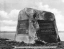
| Date: | 1913 |
|---|---|
| Description: | A monumental rock dedicated to Nathan Hale (1755-1776), schoolteacher, member of the Continental Army during the American Revolutionary war and widely rega... |

| Date: | 1777 |
|---|---|
| Description: | Map showing the Hudson River in three sections, from New York City up through Lake Champlain, including cities, forts, roads, topographical features, and n... |

| Date: | 11 1781 |
|---|---|
| Description: | Map of New York, Staten Island, and Long Island, showing the placements of forts, and the movement of troops in 1776. The map also includes towns, cities, ... |
If you didn't find the material you searched for, our Library Reference Staff can help.
Call our reference desk at 608-264-6535 or email us at: