 Filter: Categories of Wisconsin Historical Images
Filter: Subject of Harbors
Filter: Subject of peninsulas
Filter: Categories of Wisconsin Historical Images
Filter: Subject of Harbors
Filter: Subject of peninsulas
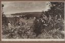
| Date: | 1920 |
|---|---|
| Description: | A well-dressed man identified as Uncle Rudolph Schenck takes in the view from a bluff overlooking the Fish Creek valley and harbor. There are houses and ou... |

| Date: | 1915 |
|---|---|
| Description: | Elevated view over a heavily wooded area to Fish Creek Harbor and Hen Island, with Peninsula State Park in the background. |

| Date: | |
|---|---|
| Description: | Exterior of the menu for Paul's Cafe, with a bird's-eye view map of "Washburn's Natural Deep Water Land Locked Harbor," Chequamegon Bay, and the Apostle Is... |
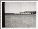
| Date: | 04 17 1963 |
|---|---|
| Description: | Egg Harbor pier. The shoreline and trees are on the right. There is a cottage area along the shoreline along with a small beach. |

| Date: | 01 06 1958 |
|---|---|
| Description: | Ahnapee & Western Railway Bridge from north side of frozen Sturgeon Bay. The bridge is made of wood (and steel supports???). There is a dock in the foregro... |

| Date: | 1630 |
|---|---|
| Description: | One of the few maps by Dutch cartographer Willem Blaeu depicting the Americas, this map shows regions, settlements, islands, mountains, forests, rivers, an... |

| Date: | 1763 |
|---|---|
| Description: | Map showing the new British territories of East and West Florida following the Treaty of Paris at the end of the French and Indian War. It shows boundaries... |

| Date: | 1916 |
|---|---|
| Description: | Text on front reads: "North Point — Sheboygan, Wis." Elevated view of a Niagara limestone shelf of rock that rises above Lake Michigan. This rarely occurs ... |
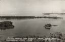
| Date: | 1940 |
|---|---|
| Description: | Text on front reads: "Sawyer Harbor and Cabot's Point from Tower, Potowatomi State Park, Door County, Wis." Elevated view across Sawyer Harbor towards Stur... |
If you didn't find the material you searched for, our Library Reference Staff can help.
Call our reference desk at 608-264-6535 or email us at: