 Filter: Categories of Wisconsin Historical Images
Filter: Subject of Harbors
Filter: Subject of mississippi river
Filter: Categories of Wisconsin Historical Images
Filter: Subject of Harbors
Filter: Subject of mississippi river

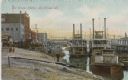
| Date: | 1873 |
|---|---|
| Description: | The harbor, showing the sidewheel packet, "Belle of La Crosse," and the sidewheel ferry "Alex McGregor." Other boats are also seen including two barges loa... |
| Date: | |
|---|---|
| Description: | Harbor full of steamboats. The shoreline is bustling with people walking amidst the buildings, piers and bridges. Caption reads: "La Crosse Harbor, La Cros... |
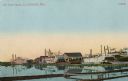
| Date: | |
|---|---|
| Description: | Old boat yards, with numerous steamboats, and buildings on the shoreline. Caption reads: "Old Boat Yards, La Crosse, Wis." |
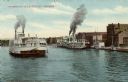
| Date: | 1903 |
|---|---|
| Description: | Several steamboats in the harbor, with J.J. Hogan Wholesale Grocery store and other buildings along the shoreline. Caption reads: "Steamboats in La Crosse ... |

| Date: | 1970 |
|---|---|
| Description: | This map is intended for tourists of La Crosse. The cover features images of farms and natural land and reads: "friends are but strangers... we have yet to... |
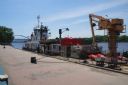
| Date: | 2012 |
|---|---|
| Description: | United States Coast Guard boat and a dredging barge at the Riverside Park, Levee Dock, a United States port facility on the Mississippi River. A brick walk... |

| Date: | 01 01 1959 |
|---|---|
| Description: | This map shows many of the rivers, dams, bays, harbors, lakes, and canals. It includes an index of authorized federal project, both for navigation and floo... |

| Date: | 1719 |
|---|---|
| Description: | Map of the British colonies and territories in North American, depicting cities, Native American land, rivers, mines, forts, trees, and topography east of ... |

| Date: | 1763 |
|---|---|
| Description: | Map showing the new British territories of East and West Florida following the Treaty of Paris at the end of the French and Indian War. It shows boundaries... |
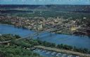
| Date: | |
|---|---|
| Description: | Photographic postcard of an aerial view over La Crosse and the I-90 Interstate bridge. French Island is in the foreground. |

| Date: | 1908 |
|---|---|
| Description: | View across water towards the La Crosse Harbor. On the right are two people in a small excursion boat. Along the shoreline is the paddle steamer "St. Paul,... |
If you didn't find the material you searched for, our Library Reference Staff can help.
Call our reference desk at 608-264-6535 or email us at: