 Filter: Categories of Wisconsin Historical Images
Filter: Subject of Harbors
Filter: Subject of michigan, lake
Filter: Subject of lakes
Filter: Categories of Wisconsin Historical Images
Filter: Subject of Harbors
Filter: Subject of michigan, lake
Filter: Subject of lakes
| Date: | 1895 |
|---|---|
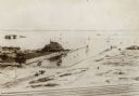
| Description: | View from across railroad tracks. Resort is on the water's edge, with a small inlet on the right. Land is mostly sand, though a small part on the left ha... |

| Date: | 1907 |
|---|---|
| Description: | Text on front reads: "Racine, Wis. in 1850." Artist's rendering of the view of the harbor with sailing ships, sailboats, rowboats and canoes. The Main Stre... |

| Date: | |
|---|---|
| Description: | View across the water of the mouth of the harbor with boats in Chicago. |

| Date: | 1880 |
|---|---|
| Description: | Map of Wisconsin including the eastern portions on Minnesota, Iowa, northern Illinois, and the western most portion of Michigan’s Upper Peninsula, showing ... |

| Date: | 1951 |
|---|---|
| Description: | This map is a survey of Lake Michigan and the section of Milwaukee that borders the lake. Map of land includes major streets, and landmarks near water. Rel... |

| Date: | 1923 |
|---|---|
| Description: | This map shows major cities surrounding the Great Lakes. Portions of Minnesota, Iowa, Illinois, Indiana, Ohio, Michigan, New York, Vermont, Massachusetts,C... |

| Date: | 1923 |
|---|---|
| Description: | This map includes an explanation that reads: "This chart shows the movement of oats on the Great Lakes, St. Lawrence River, and New York State Barge Canal ... |

| Date: | 1926 |
|---|---|
| Description: | This blueprint map shows the land and its uses near Two Rivers Harbor. Lake Michigan is labeled on the left. Roads and buildings are also labeled. Original... |

| Date: | 1831 |
|---|---|
| Description: | This map shows the land that makes up Michigan, Wisconsin, Minnesota, Indiana, and parts of Canada. The Great Lakes are displayed prominently, along with s... |

| Date: | 01 01 1959 |
|---|---|
| Description: | This map shows many of the rivers, dams, bays, harbors, lakes, and canals. It includes an index of authorized federal project, both for navigation and floo... |

| Date: | 1719 |
|---|---|
| Description: | Map of the British colonies and territories in North American, depicting cities, Native American land, rivers, mines, forts, trees, and topography east of ... |

| Date: | 1915 |
|---|---|
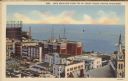
| Description: | Text at top reads: "Racine, Wis. View from Top of Court-House." An elevated view of Racine including the harbor. Buildings, rooftops, signs, the gas works ... |
| Date: | 11 05 1943 |
|---|---|
| Description: | Text at top reads: "Lake Michigan from Top of Court House, Racine, Wisconsin." An elevated view of Racine including the harbor. Buildings, rooftops, signs,... |
| Date: | 1952 |
|---|---|
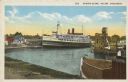
| Description: | Text on front reads: "Harbor Scene, Racine Wisconsin." A large ship is docked in Racine's harbor, with another ship and harbor facilities. |

| Date: | 1916 |
|---|---|
| Description: | Text on front reads: "North Point — Sheboygan, Wis." Elevated view of a Niagara limestone shelf of rock that rises above Lake Michigan. This rarely occurs ... |
If you didn't find the material you searched for, our Library Reference Staff can help.
Call our reference desk at 608-264-6535 or email us at: