Filter: Categories of Wisconsin Historical Images
Filter: Subject of Harbors
Filter: Subject of land use
Filter: Subject of roads
Filter: Categories of Wisconsin Historical Images
Filter: Subject of Harbors
Filter: Subject of land use
Filter: Subject of roads

| Date: | 1857 |
|---|---|
| Description: | From Judge Smith Addition, 5th Ward, looking north, toward the city. Drawing is an elevated view of field and plank fence in foreground, road to the left a... |
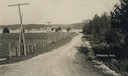
| Date: | 1905 |
|---|---|
| Description: | A lane in Ephraim with power lines lining the road. There is a body of water in the distance with houses on the far shoreline. |
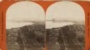
| Date: | 1876 |
|---|---|
| Description: | Stereograph. Elevated view looking roughly south, the foreground overlooks a residential neighborhood. On the far shoreline, smoke clouds spew out from lar... |

| Date: | 1953 |
|---|---|
| Description: | Aerial view looking north from the foot of Milwaukee's main thoroughfare, Wisconsin Avenue. Lincoln Memorial Drive winds its way along the lagoon in Juneau... |

| Date: | |
|---|---|
| Description: | An aerial view of the port and a section of the city showing a large boat, a railway depot, a park plaza and a grid of city streets with large buildings. |
| Date: | |
|---|---|
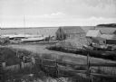
| Description: | General view of town streets, with a harbor and early American store exteriors. |
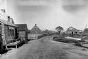
| Date: | 1925 |
|---|---|
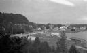
| Description: | Elevated view of Fish Creek from the east; the bluff rises on the left, the harbor is on the right. The cottage in the foreground with pergola and lattice ... |

| Date: | 1916 |
|---|---|
| Description: | This Wisconsin Conservation Commission map from 1916 shows Peninsula State Park in the Town of Gibraltar, Door County, Wisconsin. Depicted are open and pla... |

| Date: | 1916 |
|---|---|
| Description: | This version of a 1916 Wisconsin Conservation Commission map shows Peninsula State Park in the Town of Gibraltar, Door County, Wisconsin. Depicted are open... |
| Date: | 1915 |
|---|---|
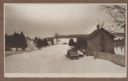
| Description: | Winter scene from Egg Harbor Road (Highway 42) in Fish Creek looking north toward frozen Fish Creek Harbor with the bluffs in Peninsula State Park beyond. ... |

| Date: | 1941 |
|---|---|
| Description: | Elevated view of Sturgeon Bay in 1900. Sturgeon Bay Bridge spans the bay and several boats are on the water. A lighthouse sits on a small island in the bay... |
If you didn't find the material you searched for, our Library Reference Staff can help.
Call our reference desk at 608-264-6535 or email us at: