 Filter: Categories of Wisconsin Historical Images
Filter: Subject of Harbors
Filter: Subject of land
Filter: Subject of ships
Filter: Categories of Wisconsin Historical Images
Filter: Subject of Harbors
Filter: Subject of land
Filter: Subject of ships

| Date: | 1886 |
|---|---|
| Description: | Bird's-eye view of Ashland, on the shores of Lake Superior, with insets of The Apostle Islands Chequamagon Bay & Ashland, and Distances from Ashland. |

| Date: | 1913 |
|---|---|
| Description: | Bird's-eye map of Superior. "The New Steel Center." |

| Date: | 1892 |
|---|---|
| Description: | Bird's-eye view of Chicago, with ships in the Lake Michigan harbor. |

| Date: | 1892 |
|---|---|
| Description: | Bird's-eye view of the Columbian Exposition pavilions from the vantage point of Lake Michigan. Included is an inset of the Union Passenger Station (now Uni... |

| Date: | 1913 |
|---|---|
| Description: | Aerial bridge and harbor, with a large boat passing underneath. A lamppost and a beacon are along the walkway towards the bridge on the left. Caption reads... |

| Date: | 1866 |
|---|---|
| Description: | Exterior of Fort Sumter. A cannon has fallen on the steep shoreline and waves are hitting the rocks. Plate 58 |

| Date: | 09 1951 |
|---|---|
| Description: | A sampan boat in Hong Kong harbor. Perhaps what caught the photographer's eye was the laundry on the boat hanging out to dry. |

| Date: | |
|---|---|
| Description: | View of the S.S. "Spokane" on Glacier Bay. Mountains rise in the background. Caption reads: "S.S. "Spokane" in Glacier Bay, Alaska." |

| Date: | |
|---|---|
| Description: | Bird's-eye view lithograph of Key West with ships and smaller boats in the surrounding waters. |

| Date: | |
|---|---|
| Description: | Elevated view of the city and the surrounding bay and hills. Text reads, "Terminus of Alaska C.R.R." |

| Date: | |
|---|---|
| Description: | Elevated general view of the city with harbor and mountains. A ship is docked near the railroad bridge. |

| Date: | |
|---|---|
| Description: | General view of the city's shoreline featuring a ship moored at the main pier. |
| Date: | |
|---|---|
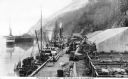
| Description: | View of Moore's Wharf with shipments standing on it, including pens with livestock. |

| Date: | 02 05 1944 |
|---|---|
| Description: | General view of Port Moresby Harbor from road, New Guinea (present day Papua New Guinea). A jeep is on the road on the left. Several soldiers are near a sh... |

| Date: | 1941 |
|---|---|
| Description: | Elevated view of Sturgeon Bay in 1900. Sturgeon Bay Bridge spans the bay and several boats are on the water. A lighthouse sits on a small island in the bay... |

| Date: | 01 08 1958 |
|---|---|
| Description: | Elevated view over icy water towards ships in the shipyard on the left, and the cement company in the background. Cranes and industrial buildings are in th... |
| Date: | |
|---|---|
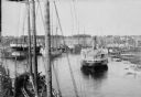
| Description: | Elevated view of commercial boats in Manitowoc Harbor. |

| Date: | 1630 |
|---|---|
| Description: | One of the few maps by Dutch cartographer Willem Blaeu depicting the Americas, this map shows regions, settlements, islands, mountains, forests, rivers, an... |

| Date: | 1733 |
|---|---|
| Description: | This map of North America shows settlements, rivers, lakes, Native American land, trade winds, and numerous topographical features such as forests and moun... |
If you didn't find the material you searched for, our Library Reference Staff can help.
Call our reference desk at 608-264-6535 or email us at:
