 Filter: Categories of Wisconsin Historical Images
Filter: Subject of Harbors
Filter: Subject of land
Filter: Creator Name of Unknown
Filter: Categories of Wisconsin Historical Images
Filter: Subject of Harbors
Filter: Subject of land
Filter: Creator Name of Unknown

| Date: | 1913 |
|---|---|
| Description: | Aerial bridge and harbor, with a large boat passing underneath. A lamppost and a beacon are along the walkway towards the bridge on the left. Caption reads... |

| Date: | 1915 |
|---|---|
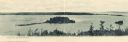
| Description: | View from hill across Eagle Bay with buildings and trees in the foreground. Caption reads: "Across Eagle Bay, Ephraim, Wis." |
| Date: | 1929 |
|---|---|
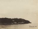
| Description: | One of the four harbors on Washington Island. There is a man on a pier or dock in the foreground, and a boat approaching on the left. A tree-lined shorelin... |
| Date: | 1910 |
|---|---|
| Description: | View of Sawyer Harbor as seen from Government Bluff. |
| Date: | 1900 |
|---|---|
| Description: | View across water of a dock and buildings on Lake Michigan. |

| Date: | |
|---|---|
| Description: | Panoramic collotype of Havana, Cuba harbor. Numerous boats are visible. Sky appears to have been masked out before printing. |

| Date: | 1950 |
|---|---|
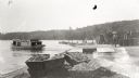
| Description: | Harbor area of Jones Island and garbage disposal plant, Stratton Grain Co., and more. |

| Date: | |
|---|---|
| Description: | View from shoreline of boats docked at the fishing wharf. People are fishing from the pier, and a group of people are in a rowboat near a ferry. There are ... |
| Date: | |
|---|---|
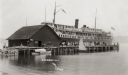
| Description: | View across water towards a large ferry docked at the fishing wharf. A large group of people are standing on the pier, and passengers are standing at the r... |
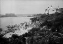
| Date: | 1930 |
|---|---|
| Description: | View along top of rocky cliff toward a home on the right overlooking the ocean, with a large building further down the curving shoreline in the distance. |
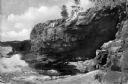
| Date: | 1940 |
|---|---|
| Description: | View of Anemone Cave and crashing waves, surrounded by coastal rock formations. |
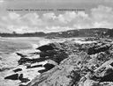
| Date: | 1925 |
|---|---|
| Description: | View along rocky coastline with crashing waves. Buildings are along the shoreline in the distance. Caption reads: "View from Ye Headland Inn. Trefethen, Ma... |
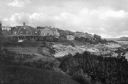
| Date: | 1920 |
|---|---|
| Description: | View along top of cliff toward cottages along a rocky coast. A large building is in the distance on the right. |

| Date: | |
|---|---|
| Description: | Elevated view of Fort Seward from Mount Rippinsky, showing Pyramid Harbor and Davidson Glacier in distance. Caption reads: "Haines and Fort Wm. H. Seward f... |

| Date: | 1920 |
|---|---|
| Description: | View across harbor filled with boats toward small wooden cottages along the far shoreline. A rock wall along the water's edge is in the foreground on the r... |
| Date: | |
|---|---|
| Description: | Elevated view from hill of a harbor with docks and shacks along the shoreline. |
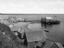
| Date: | |
|---|---|
| Description: | A view toward a wharf with horse-drawn vehicles in the foreground, and a steamship in the distance. |

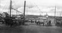
| Date: | |
|---|---|
| Description: | Elevated view of village homes on the shores of the bay with docked fishing boats in the foreground. Caption reads, "Marblehead, Mass from Rockmere Point." |
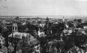
| Date: | |
|---|---|
| Description: | Elevated view looking down on the town with the bay and opposite shoreline in distance. |

| Date: | |
|---|---|
| Description: | Hand-drawn map of the area at the time of Pilgrim landing, drawn by Charles Blaskowikz. Includes commemorative historical notes. |
If you didn't find the material you searched for, our Library Reference Staff can help.
Call our reference desk at 608-264-6535 or email us at: