 Filter: Categories of Wisconsin Historical Images
Filter: Subject of Harbors
Filter: Subject of lakes
Filter: Subject of political science
Filter: Categories of Wisconsin Historical Images
Filter: Subject of Harbors
Filter: Subject of lakes
Filter: Subject of political science

| Date: | 09 27 1942 |
|---|---|
| Description: | Labeled as a "freak" snowstorm. A boathouse takes up the majority of the image, with a flag flying over the boathouse. The lake is not frozen, but ice and... |

| Date: | 1907 |
|---|---|
| Description: | Text on front reads: "Racine, Wis. in 1850." Artist's rendering of the view of the harbor with sailing ships, sailboats, rowboats and canoes. The Main Stre... |
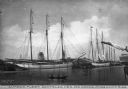
| Date: | |
|---|---|
| Description: | View of the fleet owned by Dantzler Lumber Company. Several large sailing vessels are docked, and nearby is a canoe with two passengers. Caption reads: "Lu... |

| Date: | 1720 |
|---|---|
| Description: | One of Herman Moll's most famous maps, often referred to as The Beaver Map for its elaborate engraved inset depicting and describing beavers building a dam... |

| Date: | 1715 |
|---|---|
| Description: | One of Herman Moll's most famous maps, often referred to as The Codfish Map, it shows rivers and portages, cities, Indian villages, wind directions, routes... |

| Date: | 1720 |
|---|---|
| Description: | This map of North America shows cities, rivers, lakes, and a few topographical features, complete with numerous descriptive blocks of text about expedition... |

| Date: | 1733 |
|---|---|
| Description: | This map of North America shows settlements, rivers, lakes, Native American land, trade winds, and numerous topographical features such as forests and moun... |
If you didn't find the material you searched for, our Library Reference Staff can help.
Call our reference desk at 608-264-6535 or email us at: