 Filter: Categories of Wisconsin Historical Images
Filter: Subject of Harbors
Filter: Subject of islands
Filter: Categories of Wisconsin Historical Images
Filter: Subject of Harbors
Filter: Subject of islands

| Date: | 1935 |
|---|---|
| Description: | An International C-55 truck works to build a breakwater at Port Allen on the island of Kauai. |

| Date: | 1916 |
|---|---|
| Description: | This Wisconsin Conservation Commission map from 1916 shows Peninsula State Park in the Town of Gibraltar, Door County, Wisconsin. Depicted are open and pla... |

| Date: | 1916 |
|---|---|
| Description: | This version of a 1916 Wisconsin Conservation Commission map shows Peninsula State Park in the Town of Gibraltar, Door County, Wisconsin. Depicted are open... |

| Date: | 1915 |
|---|---|
| Description: | Elevated view over a heavily wooded area to Fish Creek Harbor and Hen Island, with Peninsula State Park in the background. |

| Date: | 1848 |
|---|---|
| Description: | Pen-and-ink on paper. The title of the map is inscribed on the back. The map shows buildings, roads, marshes, wild rice, piles and docks, deep water, and o... |

| Date: | 1941 |
|---|---|
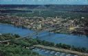
| Description: | Elevated view of Sturgeon Bay in 1900. Sturgeon Bay Bridge spans the bay and several boats are on the water. A lighthouse sits on a small island in the bay... |

| Date: | 1989 |
|---|---|
| Description: | This color coded map shows the various rivers, lakes, bays, and islands that make up the harbor. It includes an index of industries (maritime and non-marit... |

| Date: | 1936 |
|---|---|
| Description: | This map shows campsites, trails, auto roads, surrounding townships, and points of interest, by including pictorial illustrations. Includes an inserted map... |

| Date: | 1630 |
|---|---|
| Description: | One of the few maps by Dutch cartographer Willem Blaeu depicting the Americas, this map shows regions, settlements, islands, mountains, forests, rivers, an... |

| Date: | 1733 |
|---|---|
| Description: | This map of North America shows settlements, rivers, lakes, Native American land, trade winds, and numerous topographical features such as forests and moun... |

| Date: | 11 1781 |
|---|---|
| Description: | Map of New York, Staten Island, and Long Island, showing the placements of forts, and the movement of troops in 1776. The map also includes towns, cities, ... |

| Date: | 1763 |
|---|---|
| Description: | Map showing the new British territories of East and West Florida following the Treaty of Paris at the end of the French and Indian War. It shows boundaries... |
| Date: | 08 1971 |
|---|---|
| Description: | Aerial view of an ore dock next to Hog Island. The town is in the distance. In the far background are the white storage buildings of the oil refinery. |
| Date: | |
|---|---|
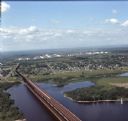
| Description: | Photographic postcard of an aerial view over La Crosse and the I-90 Interstate bridge. French Island is in the foreground. |

| Date: | 1853 |
|---|---|
| Description: | A map of Wellfleet Harbor on Cape Cod Bay. |

| Date: | 1910 |
|---|---|
| Description: | Sanborn insurance map of Milwaukee showing a portion of Jones Island with Lake Michigan at the top and the Milwaukee River at the bottom. |

| Date: | 1814 |
|---|---|
| Description: | A map of the Harbour (sic) of St. Catherine (Brazil). |
| Date: | 03 1913 |
|---|---|
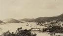
| Description: | Elevated view of the harbor at Charlotte Amalie, St. Thomas. Sailing vessels of various sizes are moored in the harbor. There are islands in the background... |

| Date: | 1897 |
|---|---|
| Description: | Circular-framed view across a body of water. Two wood pilings are in the right foreground, and a boat is out on the water. Hills are along the far shorelin... |
| Date: | 1940 |
|---|---|
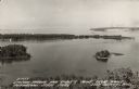
| Description: | Text on front reads: "Sawyer Harbor and Cabot's Point from Tower, Potowatomi State Park, Door County, Wis." Elevated view across Sawyer Harbor towards Stur... |
If you didn't find the material you searched for, our Library Reference Staff can help.
Call our reference desk at 608-264-6535 or email us at: