 Filter: Categories of Wisconsin Historical Images
Filter: Subject of Harbors
Filter: Subject of islands
Filter: Subject of ships
Filter: Categories of Wisconsin Historical Images
Filter: Subject of Harbors
Filter: Subject of islands
Filter: Subject of ships

| Date: | 1886 |
|---|---|
| Description: | Bird's-eye view of Ashland, on the shores of Lake Superior, with insets of The Apostle Islands Chequamagon Bay & Ashland, and Distances from Ashland. |

| Date: | 1892 |
|---|---|
| Description: | Bird's-eye view of the Columbian Exposition pavilions from the vantage point of Lake Michigan. Included is an inset of the Union Passenger Station (now Uni... |

| Date: | |
|---|---|
| Description: | Bird's-eye view lithograph of Key West with ships and smaller boats in the surrounding waters. |

| Date: | 1941 |
|---|---|
| Description: | Elevated view of Sturgeon Bay in 1900. Sturgeon Bay Bridge spans the bay and several boats are on the water. A lighthouse sits on a small island in the bay... |

| Date: | 1630 |
|---|---|
| Description: | One of the few maps by Dutch cartographer Willem Blaeu depicting the Americas, this map shows regions, settlements, islands, mountains, forests, rivers, an... |

| Date: | 1733 |
|---|---|
| Description: | This map of North America shows settlements, rivers, lakes, Native American land, trade winds, and numerous topographical features such as forests and moun... |
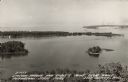
| Date: | 1940 |
|---|---|
| Description: | Text on front reads: "Sawyer Harbor and Cabot's Point from Tower, Potowatomi State Park, Door County, Wis." Elevated view across Sawyer Harbor towards Stur... |
If you didn't find the material you searched for, our Library Reference Staff can help.
Call our reference desk at 608-264-6535 or email us at: