 Filter: Categories of Wisconsin Historical Images
Filter: Subject of Harbors
Filter: Subject of islands
Filter: Subject of architecture
Filter: Categories of Wisconsin Historical Images
Filter: Subject of Harbors
Filter: Subject of islands
Filter: Subject of architecture

| Date: | 1910 |
|---|---|
| Description: | Bird's-eye view looking east, with Washburn Harbor at center and Chequamegon Bay in Lake Superior covering most of the upper image. Streets with buildings... |

| Date: | 1892 |
|---|---|
| Description: | Bird's-eye view of the Columbian Exposition pavilions from the vantage point of Lake Michigan. Included is an inset of the Union Passenger Station (now Uni... |
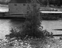
| Date: | 10 19 1964 |
|---|---|
| Description: | Cedar tree on shoreline looking out to an old pier over pilings and rocks. There is a building or boathouse on it. This is a former fishing settlement west... |

| Date: | |
|---|---|
| Description: | Distant view of the city from the mountains, looking out over the bay. Mountains can be seen across the water. Copyright by Winter & Pond. |

| Date: | 1916 |
|---|---|
| Description: | This Wisconsin Conservation Commission map from 1916 shows Peninsula State Park in the Town of Gibraltar, Door County, Wisconsin. Depicted are open and pla... |

| Date: | 1916 |
|---|---|
| Description: | This version of a 1916 Wisconsin Conservation Commission map shows Peninsula State Park in the Town of Gibraltar, Door County, Wisconsin. Depicted are open... |

| Date: | 1941 |
|---|---|
| Description: | Elevated view of Sturgeon Bay in 1900. Sturgeon Bay Bridge spans the bay and several boats are on the water. A lighthouse sits on a small island in the bay... |
If you didn't find the material you searched for, our Library Reference Staff can help.
Call our reference desk at 608-264-6535 or email us at: