 Filter: Categories of Wisconsin Historical Images
Filter: Subject of Harbors
Filter: Subject of intellectual life
Filter: Categories of Wisconsin Historical Images
Filter: Subject of Harbors
Filter: Subject of intellectual life

| Date: | 1886 |
|---|---|
| Description: | Bird's-eye view of Ashland, on the shores of Lake Superior, with insets of The Apostle Islands Chequamagon Bay & Ashland, and Distances from Ashland. |
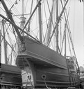
| Date: | 1893 |
|---|---|
| Description: | Columbian Exposition; under the bow of the caravel "Santa Maria." |
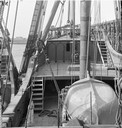
| Date: | 1893 |
|---|---|
| Description: | Columbian Exposition; on board the caravel "Santa Maria," looking aft. |

| Date: | 1913 |
|---|---|
| Description: | Bird's-eye map of Superior. "The New Steel Center." |

| Date: | 1870 |
|---|---|
| Description: | Bird's-eye view of the city of Manitowoc with a population of 5,168 inhabitants as it appears in 1870, the year the village was granted a city charter by t... |

| Date: | 1880 |
|---|---|
| Description: | Bird's-eye map of Sturgeon Bay. County Seat of Door County. |

| Date: | 1910 |
|---|---|
| Description: | Bird's-eye view looking east, with Washburn Harbor at center and Chequamegon Bay in Lake Superior covering most of the upper image. Streets with buildings... |

| Date: | 1886 |
|---|---|
| Description: | Bird's-eye view of Milwaukee from Bay View. |

| Date: | 1892 |
|---|---|
| Description: | Bird's-eye view of Chicago, with ships in the Lake Michigan harbor. |

| Date: | 1892 |
|---|---|
| Description: | Bird's-eye view of the Columbian Exposition pavilions from the vantage point of Lake Michigan. Included is an inset of the Union Passenger Station (now Uni... |
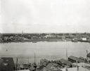
| Date: | 1903 |
|---|---|
| Description: | Aerial view of the Green Bay harbor area. |

| Date: | 1920 |
|---|---|
| Description: | Calumet Harbor on Lake Winnebago. On the left is a map, and on the right are two images, one captioned: "Calumet Harbor". |

| Date: | 04 01 1975 |
|---|---|
| Description: | The bridge over the Milwaukee Harbor named in honor of former Mayor Daniel Hoan. The bridge was constructed between 1970 and 1972, but during the period de... |

| Date: | 1951 |
|---|---|
| Description: | Aerial view of Jones Island and garbage disposal plant. |

| Date: | 1950 |
|---|---|
| Description: | Harbor area of Jones Island and garbage disposal plant, Stratton Grain Co., and more. |

| Date: | 1940 |
|---|---|
| Description: | Aerial view of city, river and harbor. Two smokestacks are on either side of the river mouth. |

| Date: | 1953 |
|---|---|
| Description: | Aerial view looking north from the foot of Milwaukee's main thoroughfare, Wisconsin Avenue. Lincoln Memorial Drive winds its way along the lagoon in Juneau... |

| Date: | |
|---|---|
| Description: | An aerial view of the port and a section of the city showing a large boat, a railway depot, a park plaza and a grid of city streets with large buildings. |
If you didn't find the material you searched for, our Library Reference Staff can help.
Call our reference desk at 608-264-6535 or email us at:

