 Filter: Categories of Wisconsin Historical Images
Filter: Subject of Harbors
Filter: Subject of intellectual life
Filter: Subject of dwellings
Filter: Categories of Wisconsin Historical Images
Filter: Subject of Harbors
Filter: Subject of intellectual life
Filter: Subject of dwellings

| Date: | 1886 |
|---|---|
| Description: | Bird's-eye view of Ashland, on the shores of Lake Superior, with insets of The Apostle Islands Chequamagon Bay & Ashland, and Distances from Ashland. |

| Date: | 1870 |
|---|---|
| Description: | Bird's-eye view of the city of Manitowoc with a population of 5,168 inhabitants as it appears in 1870, the year the village was granted a city charter by t... |

| Date: | 1892 |
|---|---|
| Description: | Bird's-eye view of Chicago, with ships in the Lake Michigan harbor. |
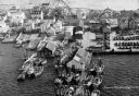
| Date: | |
|---|---|
| Description: | Aerial view of a harbor with a wharf in the foreground, and buildings and boathouses along the shoreline. |

| Date: | 1972 |
|---|---|
| Description: | Aerial view of commercial buildings and dwellings along the shore of Lake Michigan. Caption reads: "Baileys Harbor, Wisc." |

| Date: | 1720 |
|---|---|
| Description: | This map of North America shows cities, rivers, lakes, and a few topographical features, complete with numerous descriptive blocks of text about expedition... |

| Date: | 1922 |
|---|---|
| Description: | Text on front reads: "Aerial View of Sheboygan, Wis." The image shows the Sheboygan River from Lake Michigan to the Pennsylvania Avenue bridge. |
If you didn't find the material you searched for, our Library Reference Staff can help.
Call our reference desk at 608-264-6535 or email us at:

