 Filter: Categories of Wisconsin Historical Images
Filter: Subject of Harbors
Filter: Subject of hills
Filter: Categories of Wisconsin Historical Images
Filter: Subject of Harbors
Filter: Subject of hills

| Date: | 1913 |
|---|---|
| Description: | Bird's-eye map of Superior. "The New Steel Center." |
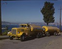
| Date: | 1951 |
|---|---|
| Description: | Color photograph of an International LD-400 series tanker truck owned by Eastern Washington Transports, Inc., on a road near the Port of Seattle. |

| Date: | 1913 |
|---|---|
| Description: | Aerial bridge and harbor, with a large boat passing underneath. A lamppost and a beacon are along the walkway towards the bridge on the left. Caption reads... |

| Date: | 1915 |
|---|---|
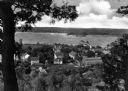
| Description: | View from hill across Eagle Bay with buildings and trees in the foreground. Caption reads: "Across Eagle Bay, Ephraim, Wis." |
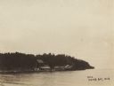
| Date: | 1910 |
|---|---|
| Description: | View of Sawyer Harbor as seen from Government Bluff. |
| Date: | 1900 |
|---|---|
| Description: | View across water of a dock and buildings on Lake Michigan. |

| Date: | |
|---|---|
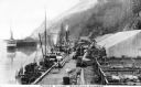
| Description: | View from shoreline of boats docked at the fishing wharf. People are fishing from the pier, and a group of people are in a rowboat near a ferry. There are ... |
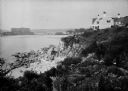
| Date: | 1930 |
|---|---|
| Description: | View along top of rocky cliff toward a home on the right overlooking the ocean, with a large building further down the curving shoreline in the distance. |
| Date: | 1920 |
|---|---|
| Description: | View along top of cliff toward cottages along a rocky coast. A large building is in the distance on the right. |

| Date: | 1920 |
|---|---|
| Description: | View across harbor filled with boats toward small wooden cottages along the far shoreline. A rock wall along the water's edge is in the foreground on the r... |
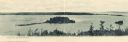
| Date: | |
|---|---|
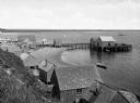
| Description: | Elevated view from hill of a harbor with docks and shacks along the shoreline. |

| Date: | |
|---|---|
| Description: | Elevated view of village homes on the shores of the bay with docked fishing boats in the foreground. Caption reads, "Marblehead, Mass from Rockmere Point." |
| Date: | |
|---|---|
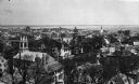
| Description: | Elevated view looking down on the town with the bay and opposite shoreline in distance. |
| Date: | |
|---|---|
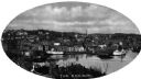
| Description: | Elevated view of Norwich harbor. Oval-framed view features two ships in the river harbor as well as buildings on the waterfront and on the surrounding hill... |
| Date: | |
|---|---|
| Description: | View of a residential area of Fish Creek, looking out over Fish Creek Harbor. |

| Date: | |
|---|---|
| Description: | General view of the city's shoreline featuring a ship moored at the main pier. |
| Date: | |
|---|---|
| Description: | View of Moore's Wharf with shipments standing on it, including pens with livestock. |
| Date: | 1924 |
|---|---|
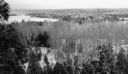
| Description: | Elevated view of a Door County landscape in winter with snow on the ground, taken from the Hotz Fish Creek cottage. Birch trees and conifers are in the for... |
| Date: | 1925 |
|---|---|
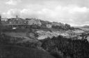
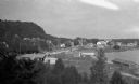
| Description: | Elevated view of Fish Creek from the east; the bluff rises on the left, the harbor is on the right. The cottage in the foreground with pergola and lattice ... |
If you didn't find the material you searched for, our Library Reference Staff can help.
Call our reference desk at 608-264-6535 or email us at:
