 Filter: Categories of Wisconsin Historical Images
Filter: Subject of Harbors
Filter: Subject of great lakes
Filter: Categories of Wisconsin Historical Images
Filter: Subject of Harbors
Filter: Subject of great lakes

| Date: | 1886 |
|---|---|
| Description: | Bird's-eye view of Ashland, on the shores of Lake Superior, with insets of The Apostle Islands Chequamagon Bay & Ashland, and Distances from Ashland. |

| Date: | 1862 |
|---|---|
| Description: | Drawn the second year of the Civil War, this 1862 map of Milwaukee shows post offices, light houses, beacon lights, county buildings, elevator warehouses, ... |
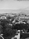
| Date: | |
|---|---|
| Description: | Elevated view south from Courthouse of rooftops, with harbor and bay in distance. |
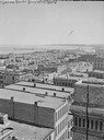
| Date: | |
|---|---|
| Description: | Milwaukee, towards South Point from Mitchell Block, E. Water Street and Michigan Street. Elevated view shows buildings and rooftops with bay and harbor in ... |
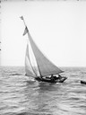
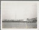
| Date: | |
|---|---|
| Description: | Several people are standing aboard a sailboat sailing in the harbor. A small boat is tied to the back of the sailboat. |
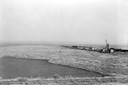
| Date: | 1936 |
|---|---|
| Description: | Elevated view of logs tugged across Lake Superior to the harbor at Ashland. |

| Date: | 1913 |
|---|---|
| Description: | Bird's-eye map of Superior. "The New Steel Center." |

| Date: | 1910 |
|---|---|
| Description: | Bird's-eye view looking east, with Washburn Harbor at center and Chequamegon Bay in Lake Superior covering most of the upper image. Streets with buildings... |

| Date: | 1892 |
|---|---|
| Description: | Bird's-eye view of the Columbian Exposition pavilions from the vantage point of Lake Michigan. Included is an inset of the Union Passenger Station (now Uni... |

| Date: | |
|---|---|
| Description: | View from shoreline of boats docked at the fishing wharf. People are fishing from the pier, and a group of people are in a rowboat near a ferry. There are ... |
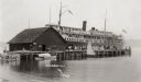
| Date: | |
|---|---|
| Description: | View across water towards a large ferry docked at the fishing wharf. A large group of people are standing on the pier, and passengers are standing at the r... |

| Date: | 1880 |
|---|---|
| Description: | Map of Wisconsin including the eastern portions on Minnesota, Iowa, northern Illinois, and the western most portion of Michigan’s Upper Peninsula, showing ... |

| Date: | 1951 |
|---|---|
| Description: | This map shows Ashland and Washburn harbors in shades of blue and yellow. Water depths shown by isolines and soundings, and relief is shown by contours. Th... |
| Date: | 07 25 1960 |
|---|---|
| Description: | Ephraim pier in Eagle Harbor. The pier is made of timbers. A dock and boathouse are on the right. Bare masts rise above the boats. The shoreline and trees ... |

| Date: | 01 06 1958 |
|---|---|
| Description: | View of the Ship Canal from the Coast Guard station. There are pieces of machinery on the right, and a line of trees on the left. There is snow on the grou... |
| Date: | 07 02 1960 |
|---|---|
| Description: | View across water towards the Manitowoc Shipbuilding floating drydock. Pilings and grass are in the foreground. On the far shoreline are buildings on a hil... |
| Date: | 01 07 1958 |
|---|---|
| Description: | View across water to ship moored at a dock. Smoke is coming out of the smokestack. Industrial buildings are across the water on the right. |
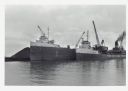
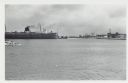
| Date: | |
|---|---|
| Description: | View across water towards ships unloading coal and sulphur. Cranes rise above both ships, and a man is walking near a large pile of coal in the background ... |

| Date: | 12 10 1957 |
|---|---|
| Description: | Pleasure boat ramps, made of timber, on the south side of Racine Harbor. A man is walking in the snow near the ramps. There are piles of material along the... |

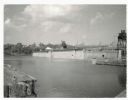
| Date: | 12 20 1957 |
|---|---|
| Description: | View across harbor from small boat ramp towards far shoreline. On the far shoreline is industrial machinery, piles of coal, and other buildings. |
If you didn't find the material you searched for, our Library Reference Staff can help.
Call our reference desk at 608-264-6535 or email us at: