 Filter: Categories of Wisconsin Historical Images
Filter: Subject of Harbors
Filter: Subject of fortification
Filter: Categories of Wisconsin Historical Images
Filter: Subject of Harbors
Filter: Subject of fortification

| Date: | |
|---|---|
| Description: | Elevated view of Fort Seward from Mount Rippinsky, showing Pyramid Harbor and Davidson Glacier in distance. Caption reads: "Haines and Fort Wm. H. Seward f... |
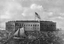
| Date: | |
|---|---|
| Description: | A painting of a harbor view of Fort Sumter. A sailboat sails through the foreground waters, and the fort is in the background, with a United States flag wa... |

| Date: | 1866 |
|---|---|
| Description: | Exterior of Fort Sumter. A cannon has fallen on the steep shoreline and waves are hitting the rocks. Plate 58 |

| Date: | 1865 |
|---|---|
| Description: | Exterior of Fort Sumpter [sic]. There are several men and a boat on the shoreline in the foreground. Plate 56 |

| Date: | 11 1781 |
|---|---|
| Description: | Map of New York, Staten Island, and Long Island, showing the placements of forts, and the movement of troops in 1776. The map also includes towns, cities, ... |

| Date: | 1814 |
|---|---|
| Description: | A map of the Harbour (sic) of St. Catherine (Brazil). |
If you didn't find the material you searched for, our Library Reference Staff can help.
Call our reference desk at 608-264-6535 or email us at: