Filter: Categories of Wisconsin Historical Images
Filter: Subject of Harbors
Filter: Subject of food industry and trade
Filter: Categories of Wisconsin Historical Images
Filter: Subject of Harbors
Filter: Subject of food industry and trade
| Date: | |
|---|---|
| Description: | Unloading barrels of goods from the "Ogdensburg" in the Milwaukee harbor. |
| Date: | 08 20 1964 |
|---|---|
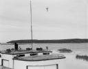
| Description: | View over fishing boat of Rock Island, as seen from Jackson Harbor. |
| Date: | |
|---|---|
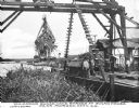
| Description: | View of several men unloading a barge of sugar cane with a crane-like tool. A river and dock area are in the background. Caption reads: "Unloading Sugar Ca... |

| Date: | |
|---|---|
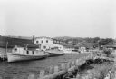
| Description: | View of a small dock and fishing boats at Norton's Pier. |

| Date: | |
|---|---|
| Description: | View of the wharf, an area crowded with boathouses, fishermen, and barrels of goods. The city's skyscrapers rise in the background. |
| Date: | 09 1925 |
|---|---|
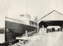
| Description: | Large cargo ship operated by the Benton Transit Company. On the dock near an open shed are many bushels of fruit, including melons and tomatoes (according ... |

| Date: | 05 1958 |
|---|---|
| Description: | Photocopy of a map created by the City of Milwaukee Master Plan Program City Planning Division in May of 1958 representing 1870 "THE CENTRAL AREA OF THE CI... |

| Date: | |
|---|---|
| Description: | Exterior of the menu for Paul's Cafe, with a bird's-eye view map of "Washburn's Natural Deep Water Land Locked Harbor," Chequamegon Bay, and the Apostle Is... |

| Date: | 1715 |
|---|---|
| Description: | One of Herman Moll's most famous maps, often referred to as The Codfish Map, it shows rivers and portages, cities, Indian villages, wind directions, routes... |
| Date: | 07 1936 |
|---|---|
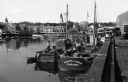
| Description: | Fishing tugs are moored alongside the wharf at Bayfield. The large Bayfield Fish Co. building is identified in large letters on the end of the building. Th... |
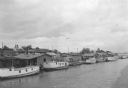
| Date: | 07 1936 |
|---|---|
| Description: | Elevated view of seagulls flying over fishing tugs moored at the wharf in Algoma. Small warehouse buildings line the wharf. Fish net drying reels are visib... |
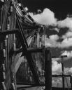
| Date: | 1963 |
|---|---|
| Description: | Fish nets and floats drying while wound onto wooden reels. Clouds are in the sky in the background. |
If you didn't find the material you searched for, our Library Reference Staff can help.
Call our reference desk at 608-264-6535 or email us at: