Filter: Categories of Wisconsin Historical Images
Filter: Subject of Harbors
Filter: Subject of fishing
Filter: Categories of Wisconsin Historical Images
Filter: Subject of Harbors
Filter: Subject of fishing
| Date: | 1935 |
|---|---|
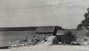
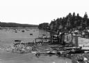
| Description: | View down road towards boats docked at the fishing wharf at Ephraim in Door County. The bluff on the horizon is in Peninsula State Park. |
| Date: | |
|---|---|
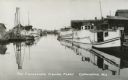
| Description: | Fishing Fleet in the harbor. Caption reads: "The Cornucopia Fishing Fleet, Cornucopia, Wis." |

| Date: | 1907 |
|---|---|
| Description: | Text on front reads: "Racine, Wis. in 1850." Artist's rendering of the view of the harbor with sailing ships, sailboats, rowboats and canoes. The Main Stre... |

| Date: | |
|---|---|
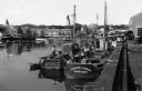
| Description: | View from shoreline of boats docked at the fishing wharf. People are fishing from the pier, and a group of people are in a rowboat near a ferry. There are ... |
| Date: | 1920 |
|---|---|
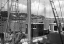
| Description: | View through buildings towards boats on water in the background. |
| Date: | 1920 |
|---|---|
| Description: | Elevated view of fishing boats moored in the harbor, with shacks along the shoreline in the foreground. |
| Date: | 1920 |
|---|---|
| Description: | A view across two fishing boats toward others moored in the harbor. |

| Date: | |
|---|---|
| Description: | View of a small dock and fishing boats at Norton's Pier. |

| Date: | |
|---|---|
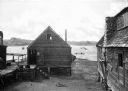
| Description: | View of the wharf, an area crowded with boathouses, fishermen, and barrels of goods. The city's skyscrapers rise in the background. |
| Date: | 1942 |
|---|---|
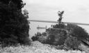
| Description: | View from rocky shoreline of two men fishing from a small boat near Toft Point. |
| Date: | 1920 |
|---|---|
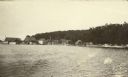
| Description: | View from the water of Washington Harbor on Washington Island. There are boats moored and warehouses along the pier. Fishing nets dry on racks on the shore... |

| Date: | 1871 |
|---|---|
| Description: | Engraved view of Kenosha harbor. A group of men fish from a pier in the foreground while several boats float through the harbor. A tug is pulling a large s... |

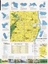
| Date: | 1970 |
|---|---|
| Description: | This map shows roads, parks, swimming beaches, golf courses, yacht harbors, light houses, airports, public hunting grounds, waysides, schools, and fishing ... |

| Date: | 1936 |
|---|---|
| Description: | This map shows campsites, trails, auto roads, surrounding townships, and points of interest, by including pictorial illustrations. Includes an inserted map... |
| Date: | 1970 |
|---|---|
| Description: | This map includes illustrations, a location map, text, lakes fishing guide, beaches, harbor and yacht clubs, and bathymetric maps of 10 lakes: Beechwood La... |

| Date: | 05 1973 |
|---|---|
| Description: | Steve Hopkins and Roger Debenham posing in Sturgeon Bay with seven trout they caught on Lake Michigan hanging from pegs under a sign that reads, "Bay Chart... |

| Date: | |
|---|---|
| Description: | Steve Hopkins and two men standing on a Bay Charter Service boat docked at the Baudhuin Yacht Harbor marina in Sturgeon Bay. The yacht club house stands be... |

| Date: | 1720 |
|---|---|
| Description: | One of Herman Moll's most famous maps, often referred to as The Beaver Map for its elaborate engraved inset depicting and describing beavers building a dam... |
If you didn't find the material you searched for, our Library Reference Staff can help.
Call our reference desk at 608-264-6535 or email us at: