 Filter: Categories of Wisconsin Historical Images
Filter: Subject of Harbors
Filter: Subject of fishing
Filter: Subject of service industries
Filter: Categories of Wisconsin Historical Images
Filter: Subject of Harbors
Filter: Subject of fishing
Filter: Subject of service industries

| Date: | 1970 |
|---|---|
| Description: | This map shows roads, parks, swimming beaches, golf courses, yacht harbors, light houses, airports, public hunting grounds, waysides, schools, and fishing ... |
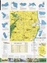
| Date: | 1970 |
|---|---|
| Description: | This map includes illustrations, a location map, text, lakes fishing guide, beaches, harbor and yacht clubs, and bathymetric maps of 10 lakes: Beechwood La... |

| Date: | 1720 |
|---|---|
| Description: | One of Herman Moll's most famous maps, often referred to as The Beaver Map for its elaborate engraved inset depicting and describing beavers building a dam... |
If you didn't find the material you searched for, our Library Reference Staff can help.
Call our reference desk at 608-264-6535 or email us at: