Filter: Categories of Wisconsin Historical Images
Filter: Subject of Harbors
Filter: Subject of fish as food
Filter: Categories of Wisconsin Historical Images
Filter: Subject of Harbors
Filter: Subject of fish as food
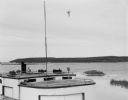
| Date: | 08 20 1964 |
|---|---|
| Description: | View over fishing boat of Rock Island, as seen from Jackson Harbor. |

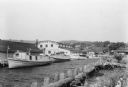
| Date: | |
|---|---|
| Description: | View of a small dock and fishing boats at Norton's Pier. |

| Date: | 1715 |
|---|---|
| Description: | One of Herman Moll's most famous maps, often referred to as The Codfish Map, it shows rivers and portages, cities, Indian villages, wind directions, routes... |
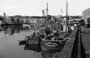
| Date: | 07 1936 |
|---|---|
| Description: | Fishing tugs are moored alongside the wharf at Bayfield. The large Bayfield Fish Co. building is identified in large letters on the end of the building. Th... |
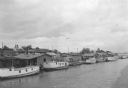
| Date: | 07 1936 |
|---|---|
| Description: | Elevated view of seagulls flying over fishing tugs moored at the wharf in Algoma. Small warehouse buildings line the wharf. Fish net drying reels are visib... |
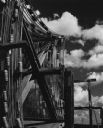
| Date: | 1963 |
|---|---|
| Description: | Fish nets and floats drying while wound onto wooden reels. Clouds are in the sky in the background. |
If you didn't find the material you searched for, our Library Reference Staff can help.
Call our reference desk at 608-264-6535 or email us at: