 Filter: Categories of Wisconsin Historical Images
Filter: Subject of Harbors
Filter: Subject of ferries
Filter: Subject of land
Filter: Categories of Wisconsin Historical Images
Filter: Subject of Harbors
Filter: Subject of ferries
Filter: Subject of land

| Date: | |
|---|---|
| Description: | View from shoreline of boats docked at the fishing wharf. People are fishing from the pier, and a group of people are in a rowboat near a ferry. There are ... |
| Date: | |
|---|---|
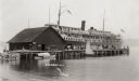
| Description: | View across water towards a large ferry docked at the fishing wharf. A large group of people are standing on the pier, and passengers are standing at the r... |

| Date: | 11 1781 |
|---|---|
| Description: | Map of New York, Staten Island, and Long Island, showing the placements of forts, and the movement of troops in 1776. The map also includes towns, cities, ... |
If you didn't find the material you searched for, our Library Reference Staff can help.
Call our reference desk at 608-264-6535 or email us at: