 Filter: Categories of Wisconsin Historical Images
Filter: Subject of Harbors
Filter: Subject of dwellings
Filter: Subject of industries
Filter: Categories of Wisconsin Historical Images
Filter: Subject of Harbors
Filter: Subject of dwellings
Filter: Subject of industries

| Date: | 1886 |
|---|---|
| Description: | Bird's-eye view of Ashland, on the shores of Lake Superior, with insets of The Apostle Islands Chequamagon Bay & Ashland, and Distances from Ashland. |
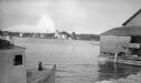
| Date: | 1907 |
|---|---|
| Description: | View across Fish Creek Harbor to the village of Fish Creek and its pier, with warehouse. On the right is Dr. Weckler's Resort, a large wooden building with... |
| Date: | 1915 |
|---|---|
| Description: | The Baileys Harbor Coast Guard Life Saving Station viewed from between a fishing boat and a pier warehouse. The station's pier extends into the harbor and ... |
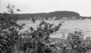
| Date: | 1924 |
|---|---|
| Description: | Elevated view of the photographer's son, Ferdinand Leonard (Fedy) sitting on the bluff overlooking Fish Creek Harbor. The old warehouses are seen on the pi... |
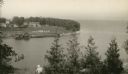
| Date: | 02 1925 |
|---|---|
| Description: | Elevated view of the abandoned town of Fayette. Snail Shell Harbor is in the foreground, with a low warehouse along the boat dock and empty buildings on th... |
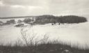
| Date: | 1915 |
|---|---|
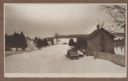
| Description: | Winter scene from Egg Harbor Road (Highway 42) in Fish Creek looking north toward frozen Fish Creek Harbor with the bluffs in Peninsula State Park beyond. ... |
| Date: | 07 02 1960 |
|---|---|
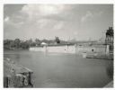
| Description: | View across water towards the Manitowoc Shipbuilding floating drydock. Pilings and grass are in the foreground. On the far shoreline are buildings on a hil... |
| Date: | 07 1936 |
|---|---|
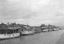
| Description: | Elevated view of seagulls flying over fishing tugs moored at the wharf in Algoma. Small warehouse buildings line the wharf. Fish net drying reels are visib... |
If you didn't find the material you searched for, our Library Reference Staff can help.
Call our reference desk at 608-264-6535 or email us at: