 Filter: Categories of Wisconsin Historical Images
Filter: Subject of Harbors
Filter: Subject of cities and towns
Filter: Subject of lighthouses
Filter: Categories of Wisconsin Historical Images
Filter: Subject of Harbors
Filter: Subject of cities and towns
Filter: Subject of lighthouses
| Date: | |
|---|---|
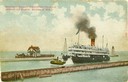
| Description: | The screw passenger excursion vessel, "Christopher Columbus," being towed into the Milwaukee harbor past a breakwater. Milwaukee North Pier Inner Light in ... |

| Date: | 1900 |
|---|---|
| Description: | A view of the lighthouse and dock office at Peshtigo Harbor. |
| Date: | |
|---|---|
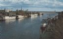
| Description: | Color photographic postcard of the fisherman's dock taken from the harbor walkway. White boats are moored on either side of the Ahnapee River as it flows i... |

| Date: | 1880 |
|---|---|
| Description: | Map of Wisconsin including the eastern portions on Minnesota, Iowa, northern Illinois, and the western most portion of Michigan’s Upper Peninsula, showing ... |

| Date: | 1911 |
|---|---|
| Description: | This map of Duluth and Superior shows street car routes, railroads, ferries, some points of interest, and lighthouses. The bottom left of the map reads: "C... |

| Date: | 1941 |
|---|---|
| Description: | Elevated view of Sturgeon Bay in 1900. Sturgeon Bay Bridge spans the bay and several boats are on the water. A lighthouse sits on a small island in the bay... |

| Date: | 01 07 1958 |
|---|---|
| Description: | View from the Second Street bridge over the icy Ahnapee River towards Lake Michigan. A lighthouse is at the end of a jetty in the far background. Boats are... |

| Date: | |
|---|---|
| Description: | Aerial view of harbor. In the foreground is a lighthouse and breakwaters. Bridges cross the harbor, and there are factory and industrial buildings near the... |

| Date: | 07 19 1854 |
|---|---|
| Description: | This map shows the shore in 1844, 1850, and 1852, the length of and proposed additions to the pier. Relief is shown by hachures and depths are shown by sou... |

| Date: | 1905 |
|---|---|
| Description: | This map shows railroads, towns, lights, lights to be established, fog signals, light-vessels, lighted buoys, light-house depots, and light-house reservati... |

| Date: | 1970 |
|---|---|
| Description: | This map shows roads, parks, swimming beaches, golf courses, yacht harbors, light houses, airports, public hunting grounds, waysides, schools, and fishing ... |

| Date: | |
|---|---|
| Description: | View of the lake front at Lakeside Park, with a lighthouse and docked boats. Caption reads: "Light House and Harbor, Lakeside Park, Fond du Lac, Wis." |

| Date: | |
|---|---|
| Description: | View toward the two lighthouses on either side of Kenosha Harbor. The lighthouse on the right has an elevated walkway to the entrance. Caption reads: "Ligh... |

| Date: | 12 22 1908 |
|---|---|
| Description: | Text reads: "Views of Racine, Wis." A collage of 12 postcards with views of buildings, landmarks and ships. |
| Date: | 1958 |
|---|---|
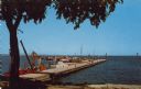
| Description: | Text on reverse reads: "Yacht Basin on Lake Michigan. Sheboygan, Wisconsin." View from shore towards a long "L" shaped concrete dock with many boats moored... |

| Date: | 03 23 1915 |
|---|---|
| Description: | Text on front reads: "Steamship William E. Corey, entering Duluth and Superior Harbor, Wis." A steamship entering the harbor under the Aerial Lift Bridge, ... |
If you didn't find the material you searched for, our Library Reference Staff can help.
Call our reference desk at 608-264-6535 or email us at: